चित्र:Kashmir region 2004.jpg

यस पूर्व रुपको आकार: ६०४ × ५९९ पिक्सल। अरु संकल्पहरू: २४२ × २४० पिक्सल • ४८४ × ४८० पिक्सल • ७७४ × ७६८ पिक्सल • १,०३२ × १,०२४ पिक्सल • १,५७९ × १,५६७ पिक्सल।
मूल फाइल (१,५७९ × १,५६७ पिक्सेलहरू, फाइल आकार: १.७१ मेगाबाइटहरू, MIME प्रकार: image/jpeg)
| यो विकिमीडिया कमन्सको चित्र हो। त्यहाँ यसको विवरण पृष्ठबाट जानकारी तल देखाइएको छ। कमन्स स्वतन्त्र रूपमा इजाजतपत्र प्राप्त चित्र भण्डार हो। तपाईंले मद्दत गर्न सक्नुहुन्छ। |
| वर्णन |
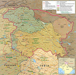
English: Kashmir Region 2004 |
|||
| मिति | ||||
| स्रोत | http://www.lib.utexas.edu/maps/middle_east_and_asia/kashmir_region_2004.jpg | |||
| लेखक | CIA | |||
| अनुमति (यो फाइल पुनप्रयोग गर्न) |
|
|||
| अरु संस्करणहरू |
 .jpg)
|


फाइल इतिहास
मिति/समय मा क्लिक गरेर त्यससमयमा यो फाइल कस्तो थियो भनेर हेर्न सकिन्छ ।
| मिति/समय | छोटो चित्र | आकारहरू | प्रयोगकर्ता | टिप्पणी | |
|---|---|---|---|---|---|
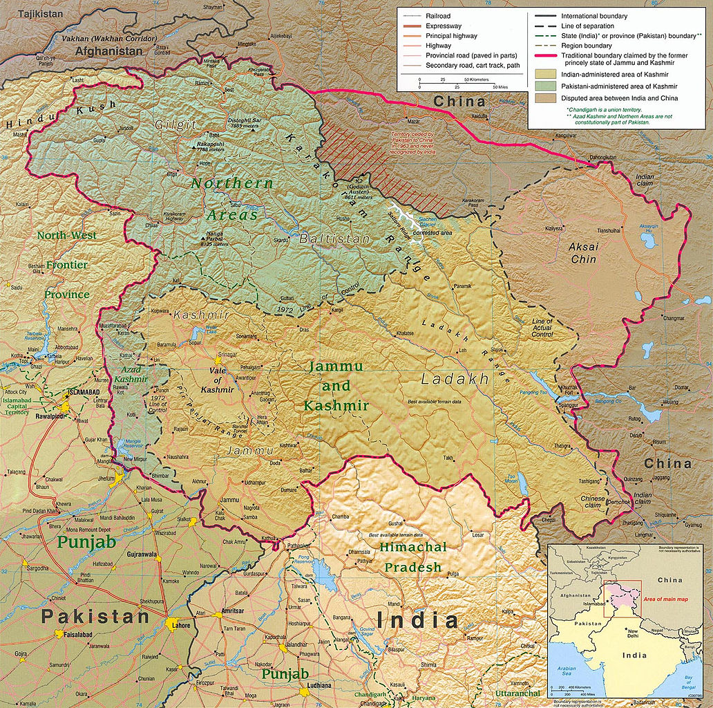
| हालको | ०३:३०, ७ जुन २०१० | | १,५७९×१,५६७ (१.७१ मेगाबाइटहरू) | Ras67 | slightly rotated and cropped |
| ००:३१, ८ मार्च २००६ |  | १,६१६×१,६२३ (७८९ किलोबाइटहरू) | Jungpionier | Kashmir Region 2004 Source URL: [http://www.lib.utexas.edu/maps/middle_east_and_asia/kashmir_region_2004.jpg]. {{PD-USGov-CIA}} |
फाइल प्रयोग
यस फाइलमा निम्न 6 पृष्ठहरू जोडिन्छन्:
विश्वव्यापी फाइल प्रयोग
निम्न अन्य विकिहरूमा यस फाइलको प्रयोग:
- af.wikipedia.org मा उपयोग
- ang.wikipedia.org मा उपयोग
- ar.wikipedia.org मा उपयोग
- arz.wikipedia.org मा उपयोग
- azb.wikipedia.org मा उपयोग
- az.wikipedia.org मा उपयोग
- be-tarask.wikipedia.org मा उपयोग
- be.wikipedia.org मा उपयोग
- bg.wikipedia.org मा उपयोग
- bh.wikipedia.org मा उपयोग
- bn.wikipedia.org मा उपयोग
- br.wikipedia.org मा उपयोग
- ca.wikipedia.org मा उपयोग
- cdo.wikipedia.org मा उपयोग
- ckb.wikipedia.org मा उपयोग
- cs.wikipedia.org मा उपयोग
- da.wikipedia.org मा उपयोग
- de.wikipedia.org मा उपयोग
- de.wikinews.org मा उपयोग
- diq.wikipedia.org मा उपयोग
- el.wikipedia.org मा उपयोग
- en.wikipedia.org मा उपयोग
यस फाइलको विश्वव्यापी उपयोगको अधिक जानकारी हेर्नुहोस् ।