चित्र:Nanga Parbat The Killer Mountain.jpg

यस पूर्व रुपको आकार: ६६२ × ६०० पिक्सल। अरु संकल्पहरू: २६५ × २४० पिक्सल • ५३० × ४८० पिक्सल • ८४८ × ७६८ पिक्सल • १,१३१ × १,०२४ पिक्सल • २,२६१ × २,०४८ पिक्सल • ५,१९० × ४,७०१ पिक्सल।
मूल फाइल (५,१९० × ४,७०१ पिक्सेलहरू, फाइल आकार: ९.०९ मेगाबाइटहरू, MIME प्रकार: image/jpeg)
| यो विकिमीडिया कमन्सको चित्र हो। त्यहाँ यसको विवरण पृष्ठबाट जानकारी तल देखाइएको छ। कमन्स स्वतन्त्र रूपमा इजाजतपत्र प्राप्त चित्र भण्डार हो। तपाईंले मद्दत गर्न सक्नुहुन्छ। |
सारांश
| वर्णन |
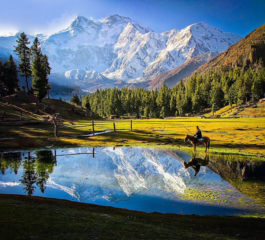
Bahasa Melayu: Nanga Prabat ialah gunung ke-9 tertinggi di dunia, dengan ketinggian 8,126 meter dari aras laut. Ia adalah penambat barat bagi pergunungan Himalaya di sekitar di mana sungai Indus menyempadani ke dataran Pakistan. English: Nanga Parbat is the ninth highest mountain in the world at 8,126 metres above sea level. It is the western anchor of the Himalayas around which the Indus river skirts into the plains of Pakistan. |
| मिति | |
| स्रोत | मेरो आफ्नै कार्य |
| लेखक | Tahsin Anwar Ali |
| अरु संस्करणहरू |
.jpg)
Assessment
|
अनुज्ञा प्राप्त गर्दै
I, the copyright holder of this work, hereby publish it under the following license:
यो फाइल क्रिएटिभ कमन्स एट्रिब्युसन-सेयर एलाइक ३.० अनपोर्टेड लाइसेन्स अनुसारको अनुमति प्राप्त छ।
- तपाईं स्वतन्त्र हुनुहुन्छ :
- साझेदारी गर्नुहाेस् – रचनालाई कपी, वितरित तथा संचारित गर्नको लागि
- रिमिक्स गर्नको लागि – काम अनुकूलित गर्नको लागि
- निम्नलिखित कारणहरूको अन्तर्गत:
- एट्रिब्युसन – तपाईंले रचनाको श्रेय अनुमतिपत्रकर्ता अथवा लेखकले बताएको माध्यमले दिनु पर्नेछ (तर यस प्रकार हैन, जसमा लागोस् की उ तपाईंलाई अथवा तपाईंको रचनाको प्रयोगलाई समर्थन गर्छन्)।
- शेयर अलाइक – यदि तपाई यस रचनामा कुनै परिवर्तन अथवा संसोधन गर्नुहुन्छ या यसमा आधारित केही रचना गर्नुहुन्छ भने तपाई निष्कर्ष स्वरूप बनेको रचनालाई मात्र यहाँ अथवा यसको समान कुनै अनिमति पत्र अन्तर्गत वितरित गर्न सक्नुहुन्छ।
यो तश्विर विकी लभ्स अर्थ २०१५को अंशको रूपमा अपलोड भएको छ।
|
 |

|
This image won the 6th prize in the national contest of Pakistan in Wiki Loves Earth 2015 Other languages:
|
फाइल इतिहास
मिति/समय मा क्लिक गरेर त्यससमयमा यो फाइल कस्तो थियो भनेर हेर्न सकिन्छ ।
| मिति/समय | छोटो चित्र | आकारहरू | प्रयोगकर्ता | टिप्पणी | |
|---|---|---|---|---|---|
| हालको | ०१:५६, १६ अगस्ट २०१७ | | ५,१९०×४,७०१ (९.०९ मेगाबाइटहरू) | Willard84 | Brightened the |
| १४:४५, ३१ मे २०१५ |  | ५,१९०×४,७०१ (१८.०९ मेगाबाइटहरू) | Tahsin Anwar Ali | User created page with UploadWizard |
फाइल प्रयोग
यस फाइलमा निम्न पृष्ठ जोडिन्छ:
विश्वव्यापी फाइल प्रयोग
निम्न अन्य विकिहरूमा यस फाइलको प्रयोग:
- ar.wikipedia.org मा उपयोग
- az.wikipedia.org मा उपयोग
- bh.wikipedia.org मा उपयोग
- bn.wikipedia.org मा उपयोग
- de.wikipedia.org मा उपयोग
- en.wikipedia.org मा उपयोग
- en.wikivoyage.org मा उपयोग
- es.wikipedia.org मा उपयोग
- eu.wikipedia.org मा उपयोग
- fa.wikipedia.org मा उपयोग
- gl.wikipedia.org मा उपयोग
- id.wikipedia.org मा उपयोग
- it.wikipedia.org मा उपयोग
- it.wikivoyage.org मा उपयोग
- ja.wikipedia.org मा उपयोग
- mk.wikipedia.org मा उपयोग
- ms.wikipedia.org मा उपयोग
- or.wikipedia.org मा उपयोग
- pl.wikipedia.org मा उपयोग
- Dyskusja wikipedysty:Polinik
- Dyskusja wikipedysty:Bloody Adam/Archiwum 3
- Dyskusja wikipedysty:Budd Le Toux
- Dyskusja wikipedysty:Gustaw1410
- Dyskusja wikipedysty:Halavar
- Dyskusja wikipedysty:Wiroid
- Dyskusja wikipedysty:Stupa1989
- Dyskusja wikipedysty:Panna Wodzianna
- Dyskusja wikipedysty:Dawid Brudniewicz
- Dyskusja wikipedysty:Tolixus
- Dyskusja wikipedysty:Stvari
- Dyskusja wikipedysty:Gregok
- Dyskusja wikipedysty:Sauron00000
यस फाइलको विश्वव्यापी उपयोगको अधिक जानकारी हेर्नुहोस् ।