चित्र:Map India and Pakistan 1-250,000 Tile NI 44-9 Pangong Tso.jpg

यस पूर्व रुपको आकार: ७९० × ५९९ पिक्सल। अरु संकल्पहरू: ३१७ × २४० पिक्सल • ६३३ × ४८० पिक्सल • १,०१३ × ७६८ पिक्सल • १,२८० × ९७१ पिक्सल • २,५६० × १,९४२ पिक्सल • ५,००० × ३,७९३ पिक्सल।
मूल फाइल (५,००० × ३,७९३ पिक्सेलहरू, फाइल आकार: ३.८१ मेगाबाइटहरू, MIME प्रकार: image/jpeg)
| यो विकिमीडिया कमन्सको चित्र हो। त्यहाँ यसको विवरण पृष्ठबाट जानकारी तल देखाइएको छ। कमन्स स्वतन्त्र रूपमा इजाजतपत्र प्राप्त चित्र भण्डार हो। तपाईंले मद्दत गर्न सक्नुहुन्छ। |
सारांश
| Description |
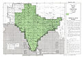
English: NI 44-9 Pangong Tso. Tile of the Map India and Pakistan 1:250,000. Series U502, U.S. Army Map Service, 1955 |
|||||||||
| मिति |
Compiled: 1954 Revised: 1962 Printed: January 1963 |
|||||||||
| स्रोत | Courtesy of the University of Texas Libraries, The University of Texas at Austin. ([1]) | |||||||||
| रचनाकार |
English: U.S. Army Map Service |
|||||||||
| Geotemporal data | ||||||||||
| Bounding box |
|
|||||||||
| Georeferencing | ||||||||||
| अरु संस्करणहरू |
|
|||||||||


-
 Index Map

![[1]](http://www.lib.utexas.edu/maps/ams/india/ni-44-09.jpg)
अनुज्ञा प्राप्त गर्दै
This image or file is a work of a U.S. Army Corps of Engineers soldier or employee, taken or made as part of that person's official duties. As a work of the U.S. federal government, the image is in the public domain.
|
फाइल इतिहास
मिति/समय मा क्लिक गरेर त्यससमयमा यो फाइल कस्तो थियो भनेर हेर्न सकिन्छ ।
| मिति/समय | छोटो चित्र | आकारहरू | प्रयोगकर्ता | टिप्पणी | |
|---|---|---|---|---|---|
| हालको | ००:५४, १२ सेप्टेम्बर २०१२ | | ५,०००×३,७९३ (३.८१ मेगाबाइटहरू) | Slick-o-bot | {{Information |Description={{en|1=NI 44-9 Pangong Tso. Tile of the Map India and Pakistan 1:250,000. Series U502, U.S. Army Map Service, 1955}} |Source=https://www.lib.utexas.edu/maps/ams/india/ [http://www.lib.utexas.edu/maps/ams/india/ni-44-09.jpg] |... |
फाइल प्रयोग
यस फाइलमा निम्न पृष्ठ जोडिन्छ:
विश्वव्यापी फाइल प्रयोग
निम्न अन्य विकिहरूमा यस फाइलको प्रयोग:
- bn.wikipedia.org मा उपयोग
- en.wikipedia.org मा उपयोग
- hi.wikipedia.org मा उपयोग
- mai.wikipedia.org मा उपयोग