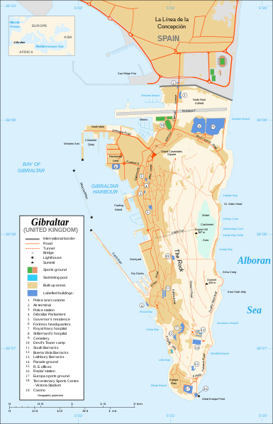
मूल फाइल(SVG फाइल,साधारण २,०२० × ३,१४० पिक्सेलहरु, फाइल आकार: २८९ किलोबाइटहरू)

Image of the year
Image of the year
Featured image

विकिमीडिया कमन्स

This file was a candidate in Picture of the Year 2007.
This is a featured picture on Wikimedia Commons (Featured pictures) and is considered one of the finest images. See its nomination here.

If you have an image of similar quality that can be published under a suitable copyright license, be sure to upload it, tag it, and nominate it.

सारांश

Camera location३६° ०८′ ००″ N, ५° २१′ ००″ W Kartographer map based on OpenStreetMap.View this and other nearby images on: OpenStreetMapinfo
वर्णन
Čeština: Mapa ostrova Gibraltar v angličtině.
English: Map in English of Gibraltar.
Français : * Sujet : Carte en anglais de Gibraltar ;
  • Sources : Création personnelle ;
  • Carte créée à partir de captures d'écran d'images satellite de Google Earth d'un point de vue placé à 1,18 km d'altitude (imagerie disponible de novembre 2007) ;
  • Références complémentaires :
  • Échelle approximative : 1:40 000 (précision : environ 10 m) ;
  • Note : Largeur du tracé des routes proportionnelle à la réalité ;
  • Auteur : Eric Gaba (fr:Sting) ;
  • Date : Novembre 2007.
Português: Mapa (em Inglês) de Gibraltar.
मिति
स्रोत Own work ;
Map created using screenshots of Google Earth satellite imagery from a point of view located at 1.18 km of altitude (available imagery of November 2007) ;
Other references :
* CIA map ;
* Gibnet map ;
* U.K. MoD map
Locator map : Image:Blank_map_of_South_Europe_and_North_Africa.svg (modified) created by Historicair ;
Approximate scale : 1:40,000 (accuracy : about 10 m)
Note : The roads width is proportional to reality
लेखक Eric Gaba (Sting)
अनुमति
(यो फाइल पुनप्रयोग गर्न)
Attribution and Share-Alike required
अरु संस्करणहरू

[सम्पादन गर्नुहोस्]

Disputed isthmus and land
SVG genesis
InfoField
 
The SVG code is valid.
 
This map was created with Inkscape…important.
 
 This map uses embedded text that can be easily translated using a text editor.

अनुज्ञा प्राप्त गर्दै

I, the copyright holder of this work, hereby publish it under the following licenses:
GNU head यस दस्तावेजलाई स्वतन्त्र सफ्टवायर फाउन्डेसन द्वारा प्रकाशित जी॰एन॰यू फ्रि डक्यूमेन्टेशन लाइसेन्स को संस्करण 1.2 वा नयाँ (बिना कुनै इन्वेरियेन्ट अनुभाग र पछिल्लो वा पहिलो आवरणका पाठका) को अन्तर्गत कपी, वितरित एवं/अथवा परिवर्तित गर्ने अनुमति प्रदान गरिन्छ । यस लाइसेन्सको एक प्रति जी॰एन॰यू फ्रि डक्यूमेन्टेशन लाइसेन्स नामक अनुभागमा शामिल छ ।
w:en:Creative Commons
एट्रिब्युसन शेयर अलाइक
This file is licensed under the Creative Commons Attribution-Share Alike 4.0 International, 3.0 Unported, 2.5 Generic, 2.0 Generic and 1.0 Generic license.
तपाईं स्वतन्त्र हुनुहुन्छ :
  • साझेदारी गर्नुहाेस् – रचनालाई कपी, वितरित तथा संचारित गर्नको लागि
  • रिमिक्स गर्नको लागि – काम अनुकूलित गर्नको लागि
निम्नलिखित कारणहरूको अन्तर्गत:
  • एट्रिब्युसन – तपाईंले रचनाको श्रेय अनुमतिपत्रकर्ता अथवा लेखकले बताएको माध्यमले दिनु पर्नेछ (तर यस प्रकार हैन, जसमा लागोस् की उ तपाईंलाई अथवा तपाईंको रचनाको प्रयोगलाई समर्थन गर्छन्)।
  • शेयर अलाइक – यदि तपाई यस रचनामा कुनै परिवर्तन अथवा संसोधन गर्नुहुन्छ या यसमा आधारित केही रचना गर्नुहुन्छ भने तपाई निष्कर्ष स्वरूप बनेको रचनालाई मात्र यहाँ अथवा यसको समान कुनै अनिमति पत्र अन्तर्गत वितरित गर्न सक्नुहुन्छ।
तपाईँ आफ्नो मनपर्ने इजाजतपत्र रोज्न सक्नुहुन्छ ।

Captions

Add a one-line explanation of what this file represents

Items portrayed in this file

जनाउँछ

copyright status अङ्ग्रेजी

copyrighted अङ्ग्रेजी

Commons quality assessment अङ्ग्रेजी

Wikimedia Commons featured picture अङ्ग्रेजी

नोभेम्बर 2007

coordinates of the point of view अङ्ग्रेजी

36°7'59.999"N, 5°21'0.000"W

MIME type अङ्ग्रेजी

image/svg+xml

फाइल इतिहास

मिति/समय मा क्लिक गरेर त्यससमयमा यो फाइल कस्तो थियो भनेर हेर्न सकिन्छ ।

मिति/समयछोटो चित्रआकारहरूप्रयोगकर्ताटिप्पणी
हालको०१:५५, २२ फेब्रुअरी २०२०छोटो चित्र ०१:५५, २२ फेब्रुअरी २०२० संस्करणको रुपमा२,०२०×३,१४० (२८९ किलोबाइटहरू)JoKalliauermalformed svg (compare firefox/chrome rendering with librsvg-rendering) actually firefox/chrome were correct, also it looks wrong
११:४६, २९ जुन २०१७छोटो चित्र ११:४६, २९ जुन २०१७ संस्करणको रुपमा२,०२०×३,१४० (५३८ किलोबाइटहरू)Wereldburger758Removal error in file. Valid SVG now.
०३:३७, २८ अगस्ट २००८छोटो चित्र ०३:३७, २८ अगस्ट २००८ संस्करणको रुपमा२,०२०×३,१४० (५६९ किलोबाइटहरू)RedCoatRemove "claimed by Spain", completely gratuitous for a map
१७:१३, ११ डिसेम्बर २००७छोटो चित्र १७:१३, ११ डिसेम्बर २००७ संस्करणको रुपमा२,०२०×३,१४० (५७० किलोबाइटहरू)StingNotification of the Spanish claims
२०:२५, २७ नोभेम्बर २००७छोटो चित्र २०:२५, २७ नोभेम्बर २००७ संस्करणको रुपमा२,०२०×३,१४० (५६९ किलोबाइटहरू)StingAdditional names ; up-to-date corrections
०३:२०, २७ नोभेम्बर २००७छोटो चित्र ०३:२०, २७ नोभेम्बर २००७ संस्करणको रुपमा२,०२०×३,१४० (५६१ किलोबाइटहरू)RedCoatHouse of Assembly → Gibraltar Parliament
०१:३६, २७ नोभेम्बर २००७छोटो चित्र ०१:३६, २७ नोभेम्बर २००७ संस्करणको रुपमा२,०२०×३,१४० (५६१ किलोबाइटहरू)Sting+ info
१९:५७, २६ नोभेम्बर २००७छोटो चित्र १९:५७, २६ नोभेम्बर २००७ संस्करणको रुपमा२,०२०×३,१४० (५६१ किलोबाइटहरू)Sting+ info
१९:०६, २६ नोभेम्बर २००७छोटो चित्र १९:०६, २६ नोभेम्बर २००७ संस्करणको रुपमा२,०२०×३,१४० (५६१ किलोबाइटहरू)Sting{{Information |Description=Map in English of Gibraltar |Source=Own work ;<br/>Map created using screenshots of Google Earth satellite imagery from a point of view located at 1.18 km of altitude (available image

यो फाइलसँग कुनै पनि पृष्ठ जोडिएको छैन।

विश्वव्यापी फाइल प्रयोग

निम्न अन्य विकिहरूमा यस फाइलको प्रयोग:

मेटाडाटा

"https://ne.wikipedia.org/wiki/चित्र:Gibraltar_map-en.svg" बाट अनुप्रेषित