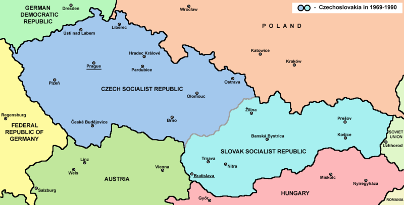
चित्र:Czechoslovakia.png

यस पूर्व रुपको आकार: ८०० × ४०७ पिक्सल। अरु संकल्पहरू: ३२० × १६३ पिक्सल • ६४० × ३२५ पिक्सल • १,१८८ × ६०४ पिक्सल।
मूल फाइल (१,१८८ × ६०४ पिक्सेलहरू, फाइल आकार: ६९ किलोबाइटहरू, MIME प्रकार: image/png)
फाइल इतिहास
मिति/समय मा क्लिक गरेर त्यससमयमा यो फाइल कस्तो थियो भनेर हेर्न सकिन्छ ।
| मिति/समय | छोटो चित्र | आकारहरू | प्रयोगकर्ता | टिप्पणी | |
|---|---|---|---|---|---|
| हालको | २०:३०, १२ जुलाई २०२२ |  | १,१८८×६०४ (६९ किलोबाइटहरू) | Sebastian Wallroth | CROPPED |
| २३:२३, १२ फेब्रुअरी २०१७ |  | १,२२१×६५२ (६९ किलोबाइटहरू) | WikiEditor2004 | Reverted to version as of 11:00, 24 April 2011 (UTC) - why you uploading polish version over english one? upload polish version under different filename | |
| २१:०३, ९ फेब्रुअरी २०१७ |  | १,२२१×६५२ (५७ किलोबाइटहरू) | Kelvin | Reverted to version as of 15:13, 9 February 2017 (UTC) | |
| २१:०२, ९ फेब्रुअरी २०१७ |  | १,२२१×६५२ (६९ किलोबाइटहरू) | Kelvin | Reverted to version as of 11:00, 24 April 2011 (UTC) | |
| २०:५८, ९ फेब्रुअरी २०१७ |  | १,२२१×६५२ (५७ किलोबाइटहरू) | Kelvin | Polish names of countries /Polskie określenia krajów | |
| १६:४५, २४ अप्रिल २०११ |  | १,२२१×६५२ (६९ किलोबाइटहरू) | WikiEditor2004 | correction | |
| १६:१२, २३ अप्रिल २०११ |  | १,२२१×६५२ (६९ किलोबाइटहरू) | WikiEditor2004 | improved version | |
| ०५:१६, ११ डिसेम्बर २००६ |  | १,२००×६२४ (१९ किलोबाइटहरू) | Severino666~commonswiki | Map of Czechoslovakia (self made) Category:Maps of Czechoslovakia Category:Maps of Czech history Category:Maps of the history of Slovakia Category:Maps of the history of Central Europe {{PD}} |
फाइल प्रयोग
यस फाइलमा निम्न पृष्ठ जोडिन्छ:
विश्वव्यापी फाइल प्रयोग
निम्न अन्य विकिहरूमा यस फाइलको प्रयोग:
- ang.wikipedia.org मा उपयोग
- an.wikipedia.org मा उपयोग
- ar.wikipedia.org मा उपयोग
- azb.wikipedia.org मा उपयोग
- az.wikipedia.org मा उपयोग
- ba.wikipedia.org मा उपयोग
- bcl.wikipedia.org मा उपयोग
- be-tarask.wikipedia.org मा उपयोग
- be.wikipedia.org मा उपयोग
- bg.wikipedia.org मा उपयोग
- bn.wikipedia.org मा उपयोग
- br.wikipedia.org मा उपयोग
- bs.wikipedia.org मा उपयोग
- ca.wikipedia.org मा उपयोग
- cv.wikipedia.org मा उपयोग
- da.wikipedia.org मा उपयोग
- de.wikipedia.org मा उपयोग
- dsb.wikipedia.org मा उपयोग
- el.wikipedia.org मा उपयोग
- en.wikipedia.org मा उपयोग
- Czechoslovakia
- History of Slovakia
- History of Czechoslovakia (1948–1989)
- History of Czechoslovakia (1989–1992)
- Economy of communist Czechoslovakia
- History of Czechoslovakia
- Dissolution of Czechoslovakia
- Czechoslovak Socialist Republic
- Portal:Slovakia
- She Grazed Horses on Concrete
- Rugby union in Czechoslovakia
यस फाइलको विश्वव्यापी उपयोगको अधिक जानकारी हेर्नुहोस् ।


