चित्र:Sanfranciscoearthquake1906.jpg

यस पूर्व रुपको आकार: ७७५ × ६०० पिक्सल। अरु संकल्पहरू: ३१० × २४० पिक्सल • ६२० × ४८० पिक्सल • ९९२ × ७६८ पिक्सल • १,२८० × ९९१ पिक्सल • १,४०८ × १,०९० पिक्सल।
मूल फाइल (१,४०८ × १,०९० पिक्सेलहरू, फाइल आकार: २७३ किलोबाइटहरू, MIME प्रकार: image/jpeg)
| यो विकिमीडिया कमन्सको चित्र हो। त्यहाँ यसको विवरण पृष्ठबाट जानकारी तल देखाइएको छ। कमन्स स्वतन्त्र रूपमा इजाजतपत्र प्राप्त चित्र भण्डार हो। तपाईंले मद्दत गर्न सक्नुहुन्छ। |
सारांश
| वर्णन |
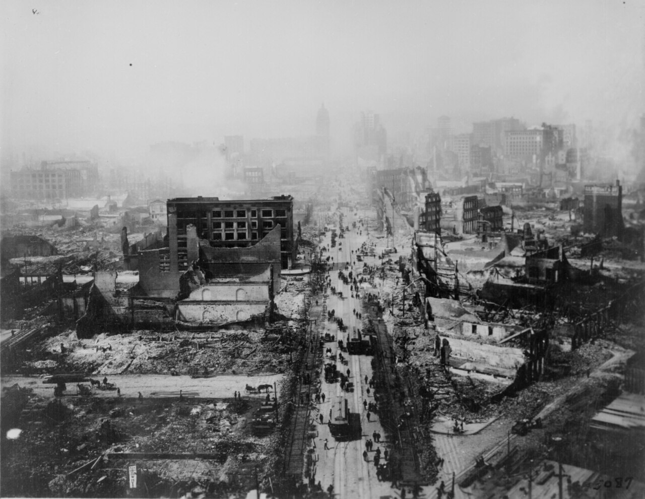
English: San Francisco, California, United States.
Smoldering after the 1906 earthquake, called the Friscoquake. Taken from the tower of the Union Ferry Building. Market Street between Sacramento and Third Streets. ARC Identifier: 531006 |
| स्रोत | Still Picture Records LICON, Special Media Archives Services Division (NWCS-S), National Archives at College Park. [1] |
| लेखक |
| Camera location | | View this and other nearby images on: OpenStreetMap |
|---|
अनुज्ञा प्राप्त गर्दै
This media file is in the public domain in the United States. This applies to U.S. works where the copyright has expired, often because its first publication occurred prior to January 1, 1929, and if not then due to lack of notice or renewal. See this page for further explanation.
|
 | |
 |
This image might not be in the public domain outside of the United States; this especially applies in the countries and areas that do not apply the rule of the shorter term for US works, such as Canada, Mainland China (not Hong Kong or Macao), Germany, Mexico, and Switzerland. The creator and year of publication are essential information and must be provided. See Wikipedia:Public domain and Wikipedia:Copyrights for more details.
|
|
This image was selected as picture of the day on Wikimedia Commons for 12 March 2007. It was captioned as follows: English: Smoldering after the 1906 earthquake in San Francisco. Taken from the tower of the Union Ferry Building. Other languages:
Deutsch: Zerstörung durch das Erdbeben im Jahre 1906 in San Francisco. Das Foto wurde vom Union Ferry Building aufgenommen. Eesti: San Francisco pärast 1906. aasta maavärinat. English: Smoldering after the 1906 earthquake in San Francisco. Taken from the tower of the Union Ferry Building. Español: Fuego tras el terremoto de 1906 de San Francisco. Tomada desde la torre del the Union Ferry Building. Esperanto: Detruita kvartalo post tertremo en 1906 en San Francisko, fotografita el turo de "Union Ferry" Français : Quartiers dévastés après le tremblement de terre de 1906 à San Francisco. Vue prise depuis la tour de l’immeuble de l’Union Ferry. Italiano: Quartiere devastato dopo il terremoto del 1906 a San Francisco. La foto è stata scattata dalla torre dell "Union Ferry". Magyar: San Francisco romjai az 1906-os nagy földrengés után Nederlands: Nasmeulende overblijfselen van San Francisco na de aardbeving van 1906. Genomen vanaf de toren van het Union Ferry-gebouw. Polski: Zniszczenia wywołane trzęsieniem ziemi w San Francisco w 1906 roku. Widok z wieży Union Ferry Building. Sicilianu: Quarteri divastatu doppu lu tirrimotu dô 1906 a San Franciscu. La fotu fu scattata dâ turri di l'"Union Ferry". Қазақша: 1906 ж. Сан-Франсискодағы жерсілкінісі Українська: Руйнування після землетрусу 1906 року у Сан-Франциско. Знімок зроблено з башти Union Ferry Building 日本語: 1906年、アメリカ合衆国カルフォルニア州サンフランシスコ周辺を襲ったサンフランシスコ地震。Union Ferryビルから撮影。 中文: 1906年旧金山大地震后的废墟,自联合轮渡公司大楼上拍摄 中文(繁體): 1906年舊金山大地震後的廢墟,自聯合渡輪公司大樓上拍攝 |
फाइल इतिहास
मिति/समय मा क्लिक गरेर त्यससमयमा यो फाइल कस्तो थियो भनेर हेर्न सकिन्छ ।
| मिति/समय | छोटो चित्र | आकारहरू | प्रयोगकर्ता | टिप्पणी | |
|---|---|---|---|---|---|
| हालको | ०९:३०, ५ मार्च २००५ | | १,४०८×१,०९० (२७३ किलोबाइटहरू) | Apollomelos~commonswiki | {{PD}} |
फाइल प्रयोग
यस फाइलमा निम्न पृष्ठ जोडिन्छ:
विश्वव्यापी फाइल प्रयोग
निम्न अन्य विकिहरूमा यस फाइलको प्रयोग:
- af.wikipedia.org मा उपयोग
- as.wikipedia.org मा उपयोग
- az.wikipedia.org मा उपयोग
- az.wiktionary.org मा उपयोग
- ba.wikipedia.org मा उपयोग
- be.wikipedia.org मा उपयोग
- bg.wikipedia.org मा उपयोग
- bs.wikipedia.org मा उपयोग
- bxr.wikipedia.org मा उपयोग
- ca.wikipedia.org मा उपयोग
- cs.wikipedia.org मा उपयोग
- da.wikipedia.org मा उपयोग
- de.wikipedia.org मा उपयोग
- el.wikipedia.org मा उपयोग
- en.wikipedia.org मा उपयोग
- en.wikinews.org मा उपयोग
- es.wikipedia.org मा उपयोग
- et.wikipedia.org मा उपयोग
- eu.wikipedia.org मा उपयोग
- fi.wikipedia.org मा उपयोग
- fr.wikipedia.org मा उपयोग
- fr.wikisource.org मा उपयोग
- fr.wiktionary.org मा उपयोग
यस फाइलको विश्वव्यापी उपयोगको अधिक जानकारी हेर्नुहोस् ।