चित्र:Geographical and Magnetic Poles.png

यस पूर्व रुपको आकार: ६६८ × ५९९ पिक्सल। अरु संकल्पहरू: २६८ × २४० पिक्सल • ५३५ × ४८० पिक्सल • ८५६ × ७६८ पिक्सल • १,०२८ × ९२२ पिक्सल।
मूल फाइल (१,०२८ × ९२२ पिक्सेलहरू, फाइल आकार: १७४ किलोबाइटहरू, MIME प्रकार: image/png)
| यो विकिमीडिया कमन्सको चित्र हो। त्यहाँ यसको विवरण पृष्ठबाट जानकारी तल देखाइएको छ। कमन्स स्वतन्त्र रूपमा इजाजतपत्र प्राप्त चित्र भण्डार हो। तपाईंले मद्दत गर्न सक्नुहुन्छ। |
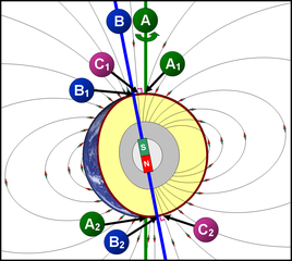
תרשים סכמטי של כדור הארץ
- A = ציר הסיבוב של כדור הארץ (מסומן בקו ירוק)
- A1 A2 = הקטבים הגאוגרפיים - הנקודות שבהן "חותך" ציר הסיבוב את פני כדור הארץ.
- הגלעין החיצוני (נוזלי) (מסומן בצבע אפור) - שכבה בכדור הארץ שבה נוצר השדה המגנטי, על פי w:he:תאוריית הדינמו.
- B = ציר הדו-קוטביות (מסומן בקו כחול) - הציר המגנטי הדו-קוטבי, המדמה מעין מוט מגנטי, שחלקו הצפוני הוא מגנט שמבחינה פיזיקלית נחשב ל"דרומי" (מסומן ב-S = South = דרום), ואילו חלקו הדרומי נחשב ל"צפוני" (N = North = צפון) מבחינה פיזיקלית. כיום, הזווית בין ציר זה לבין ציר הסיבוב של כדור הארץ היא 11.3°.
- B1 B2 = הקטבים הגאומגנטיים - הנקודות שבהן "חותך" ציר הדו-קוטביות את פני כדור הארץ.
- קווי השדה המגנטי (קווים שחורים דקים) - מתארים את כיוון השדה המגנטי מחוץ לגלעין.
- C1 C2 = הקטבים המגנטיים - הנקודות שבהן קווי השדה המגנטי (מסומנים בקווים שחורים) מאונכים לפני כדור הארץ (זווית של 90° בדיוק בגובה פני הקרקע). הקטבים המגנטיים אינם חופפים לקטבים הגאומגנטיים.
Schematic diagram of the Earth
- A = Earth's axis of rotation (marked with a green line)
- A1 A2 = the geographical poles - the points at which the axis of rotation "cuts" the axis of rotation of the earth.
- The outer core (liquid) (marked in gray) - a layer on Earth where the magnetic field is formed, according to the dynamo theory.
- B = Bipolar Axis (marked with a blue line) - The bipolar magnetic axis, which simulates a kind of magnetic rod, the northern part of which is a magnet that is physically considered "southern" (marked with S = South = South), while its southern part Is considered "North" (N = North = North) physically. Today, the angle between this axis and the axis of rotation of the Earth is 11.3 °.
- B1 B2 = the geomagnetic poles - the points at which the bipolar axis "cuts" the earth's surface.
- Magnetic field lines (thin black lines) - describe the direction of the magnetic field outside the nucleus.
- C1 C2 = The magnetic poles - the points at which the magnetic field lines (marked with black lines) are perpendicular to the Earth (an angle of 90 ° exactly at ground level). The magnetic poles do not overlap with the geomagnetic poles.
सारांश
| वर्णन | A=Geographic poles, B=Geomagnetic poles, C=Magnetic poles |
| मिति | |
| स्रोत | मेरो आफ्नै कार्य |
| लेखक | DMY |
अनुज्ञा प्राप्त गर्दै
I, the copyright holder of this work, hereby publish it under the following licenses:

|
यस दस्तावेजलाई स्वतन्त्र सफ्टवायर फाउन्डेसन द्वारा प्रकाशित जी॰एन॰यू फ्रि डक्यूमेन्टेशन लाइसेन्स को संस्करण 1.2 वा नयाँ (बिना कुनै इन्वेरियेन्ट अनुभाग र पछिल्लो वा पहिलो आवरणका पाठका) को अन्तर्गत कपी, वितरित एवं/अथवा परिवर्तित गर्ने अनुमति प्रदान गरिन्छ । यस लाइसेन्सको एक प्रति जी॰एन॰यू फ्रि डक्यूमेन्टेशन लाइसेन्स नामक अनुभागमा शामिल छ । |
This file is licensed under the Creative Commons Attribution 3.0 Unported license.
- तपाईं स्वतन्त्र हुनुहुन्छ :
- साझेदारी गर्नुहाेस् – रचनालाई कपी, वितरित तथा संचारित गर्नको लागि
- रिमिक्स गर्नको लागि – काम अनुकूलित गर्नको लागि
- निम्नलिखित कारणहरूको अन्तर्गत:
- एट्रिब्युसन – तपाईंले रचनाको श्रेय अनुमतिपत्रकर्ता अथवा लेखकले बताएको माध्यमले दिनु पर्नेछ (तर यस प्रकार हैन, जसमा लागोस् की उ तपाईंलाई अथवा तपाईंको रचनाको प्रयोगलाई समर्थन गर्छन्)।
तपाईँ आफ्नो मनपर्ने इजाजतपत्र रोज्न सक्नुहुन्छ ।
फाइल इतिहास
मिति/समय मा क्लिक गरेर त्यससमयमा यो फाइल कस्तो थियो भनेर हेर्न सकिन्छ ।
| मिति/समय | छोटो चित्र | आकारहरू | प्रयोगकर्ता | टिप्पणी | |
|---|---|---|---|---|---|
| हालको | १४:५६, १३ नोभेम्बर २००७ | | १,०२८×९२२ (१७४ किलोबाइटहरू) | DMY | |
| ०२:२८, १२ नोभेम्बर २००७ |  | १,०२८×९२२ (२११ किलोबाइटहरू) | DMY | ||
| ०२:०८, १२ नोभेम्बर २००७ |  | १,०१८×९१२ (२१० किलोबाइटहरू) | DMY | == Summary == {{Information |Description=A=Geographic poles, B=Geomagnetic poles, C=Magnetic poles |Source=self-made |Date=Nov 3, 2007 |Author= DMY |Permission= |other_versions= }} == Licensing == {{self|GFDL|cc-by-3.0}} |
फाइल प्रयोग
यस फाइलमा निम्न पृष्ठ जोडिन्छ:
विश्वव्यापी फाइल प्रयोग
निम्न अन्य विकिहरूमा यस फाइलको प्रयोग:
- ar.wikipedia.org मा उपयोग
- ast.wikipedia.org मा उपयोग
- bn.wikipedia.org मा उपयोग
- ca.wikipedia.org मा उपयोग
- cs.wikipedia.org मा उपयोग
- cy.wikipedia.org मा उपयोग
- el.wikipedia.org मा उपयोग
- en.wikipedia.org मा उपयोग
- en.wikibooks.org मा उपयोग
- eu.wikipedia.org मा उपयोग
- fr.wikipedia.org मा उपयोग
- he.wikipedia.org मा उपयोग
- ht.wikipedia.org मा उपयोग
- it.wikipedia.org मा उपयोग
- ja.wikipedia.org मा उपयोग
- ko.wikipedia.org मा उपयोग
- mk.wikipedia.org मा उपयोग
- ms.wikipedia.org मा उपयोग
- nl.wikipedia.org मा उपयोग
- nl.wikibooks.org मा उपयोग
- pl.wikipedia.org मा उपयोग
- pt.wikipedia.org मा उपयोग
- simple.wikipedia.org मा उपयोग
- sr.wikipedia.org मा उपयोग
- uz.wikipedia.org मा उपयोग
- vi.wikipedia.org मा उपयोग
- www.wikidata.org मा उपयोग