चित्र:Bodensee satellit.jpg

यस पूर्व रुपको आकार: ८०० × ४९६ पिक्सल। अरु संकल्पहरू: ३२० × १९८ पिक्सल • ६४० × ३९७ पिक्सल • १,०२४ × ६३५ पिक्सल • १,३९४ × ८६४ पिक्सल।
मूल फाइल (१,३९४ × ८६४ पिक्सेलहरू, फाइल आकार: २२४ किलोबाइटहरू, MIME प्रकार: image/jpeg)
| यो विकिमीडिया कमन्सको चित्र हो। त्यहाँ यसको विवरण पृष्ठबाट जानकारी तल देखाइएको छ। कमन्स स्वतन्त्र रूपमा इजाजतपत्र प्राप्त चित्र भण्डार हो। तपाईंले मद्दत गर्न सक्नुहुन्छ। |
सारांश
| वर्णन |
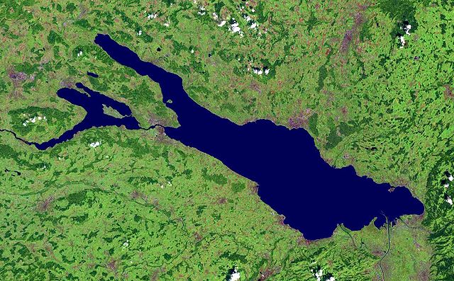
Deutsch: Satellitenaufnahme vom Bodensee |
| मिति | before १७ अगस्ट २००५ |
| स्रोत | from NASA World Wind - Free Satellite Image |
| लेखक | NASA |
सारांश
| This image is in the public domain because it is a screenshot from NASA’s globe software World Wind using a public domain layer, such as Blue Marble, MODIS, Landsat, SRTM, USGS or GLOBE.
|
 |
फाइल इतिहास
मिति/समय मा क्लिक गरेर त्यससमयमा यो फाइल कस्तो थियो भनेर हेर्न सकिन्छ ।
| मिति/समय | छोटो चित्र | आकारहरू | प्रयोगकर्ता | टिप्पणी | |
|---|---|---|---|---|---|
| हालको | २१:१३, १ डिसेम्बर २००५ | | १,३९४×८६४ (२२४ किलोबाइटहरू) | Wiki-vr | enhanced |
| ०६:२९, १७ अगस्ट २००५ |  | १,३९४×८६४ (१३८ किलोबाइटहरू) | APPER | * Satellitenaufnahme vom Bodensee * from Nasa World Wind - Free Satellite Image {{PD-USGov}} |
फाइल प्रयोग
यस फाइलमा निम्न पृष्ठ जोडिन्छ:
विश्वव्यापी फाइल प्रयोग
निम्न अन्य विकिहरूमा यस फाइलको प्रयोग:
- af.wikipedia.org मा उपयोग
- als.wikipedia.org मा उपयोग
- arz.wikipedia.org मा उपयोग
- az.wikipedia.org मा उपयोग
- ba.wikipedia.org मा उपयोग
- bg.wikipedia.org मा उपयोग
- bs.wikipedia.org मा उपयोग
- ceb.wikipedia.org मा उपयोग
- da.wikipedia.org मा उपयोग
- de.wikipedia.org मा उपयोग
- Bodensee
- Benutzer:Itta
- Mainau
- Reichenau (Insel)
- Benutzer:Rhinux
- Hoy (Bodensee)
- Werd (Bodensee)
- Benutzer:Marcel601
- Benutzer:Ralfonso
- Seerhein
- Benutzer:Trinityfolium
- Benutzer:Vorlage/Herkunftsvorlagen
- Benutzer:NicolasK
- Benutzer:Sir.toby
- Benutzer:Manerr
- Benutzer:NetCuRLi
- Galgeninsel
- Benutzer:Vorlage/vom Bodensee
- Benutzer:Shippo~dewiki
- Benutzer:Mkt.berlin88
- Benutzer:Mk-fn
- Benutzer:Widipedia
- Benutzer:Zollernalb
- Portal:Ungarn/Quiz
- Benutzer:Manu-LA
- Benutzer:Vorlage/Herkunftsvorlagen/Baden-Württemberg
- Benutzer:Vorlage/Herkunftsvorlagen/Bayern
- Bodensee-Rundweg
- Benutzer:TwilightFreak
- Benutzer:Master baerr
- Benutzer:MP Trixi
- Benutzer:Weber Mi
- Benutzer:Hintze
- Benutzer:KMJagger
- Benutzer:Sweet Chily
- Benutzer:Maasty
- Benutzer:Rudolf von Rheinfelden/Labor/Artikelbaustelle 2
यस फाइलको विश्वव्यापी उपयोगको अधिक जानकारी हेर्नुहोस् ।