चित्र:SakastanMap.jpg

यस पूर्व रुपको आकार: ७३३ × ५९९ पिक्सल। अरु संकल्पहरू: २९४ × २४० पिक्सल • ५८७ × ४८० पिक्सल • ९३९ × ७६८ पिक्सल • १,२५२ × १,०२४ पिक्सल • १,३५६ × १,१०९ पिक्सल।
मूल फाइल (१,३५६ × १,१०९ पिक्सेलहरू, फाइल आकार: २५८ किलोबाइटहरू, MIME प्रकार: image/jpeg)
| यो विकिमीडिया कमन्सको चित्र हो। त्यहाँ यसको विवरण पृष्ठबाट जानकारी तल देखाइएको छ। कमन्स स्वतन्त्र रूपमा इजाजतपत्र प्राप्त चित्र भण्डार हो। तपाईंले मद्दत गर्न सक्नुहुन्छ। |

|
This historical map image could be re-created using vector graphics as an SVG file. This has several advantages; see Commons:Media for cleanup for more information. If an SVG form of this image is available, please upload it and afterwards replace this template with
{{vector version available|new image name}}.
It is recommended to name the SVG file “SakastanMap.svg”—then the template Vector version available (or Vva) does not need the new image name parameter. |


सारांश
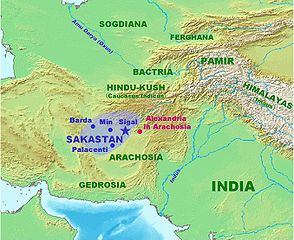
| वर्णन | Map of Sakastan circa 100 BCE. Own work. |
| मिति | २१ जनवरी २००७ (original upload date) |
| स्रोत | No machine-readable source provided. Own work assumed (based on copyright claims). |
| लेखक | No machine-readable author provided. World Imaging assumed (based on copyright claims). |
अनुज्ञा प्राप्त गर्दै
| I, the copyright holder of this work, release this work into the public domain. This applies worldwide. In some countries this may not be legally possible; if so: I grant anyone the right to use this work for any purpose, without any conditions, unless such conditions are required by law. |
फाइल इतिहास
मिति/समय मा क्लिक गरेर त्यससमयमा यो फाइल कस्तो थियो भनेर हेर्न सकिन्छ ।
| मिति/समय | छोटो चित्र | आकारहरू | प्रयोगकर्ता | टिप्पणी | |
|---|---|---|---|---|---|
| हालको | ०३:०७, २२ जनवरी २००७ | | १,३५६×१,१०९ (२५८ किलोबाइटहरू) | World Imaging | More precise map, with Arachosia. |
| ०२:५०, २२ जनवरी २००७ |  | १,३५३×१,११२ (२६० किलोबाइटहरू) | World Imaging | Map of Sakastan circa 100 BCE. Own work. |
फाइल प्रयोग
यस फाइलमा निम्न पृष्ठ जोडिन्छ:
विश्वव्यापी फाइल प्रयोग
निम्न अन्य विकिहरूमा यस फाइलको प्रयोग:
- af.wikipedia.org मा उपयोग
- arz.wikipedia.org मा उपयोग
- bcl.wikipedia.org मा उपयोग
- ca.wikipedia.org मा उपयोग
- cs.wikipedia.org मा उपयोग
- de.wikipedia.org मा उपयोग
- diq.wikipedia.org मा उपयोग
- en.wikipedia.org मा उपयोग
- eo.wikipedia.org मा उपयोग
- es.wikipedia.org मा उपयोग
- et.wikipedia.org मा उपयोग
- fa.wikipedia.org मा उपयोग
- hi.wikipedia.org मा उपयोग
- hu.wikipedia.org मा उपयोग
- incubator.wikimedia.org मा उपयोग
- it.wikipedia.org मा उपयोग
- ka.wikipedia.org मा उपयोग
- ml.wikipedia.org मा उपयोग
- nl.wikipedia.org मा उपयोग
- pl.wikipedia.org मा उपयोग
- pl.wiktionary.org मा उपयोग
- ro.wikipedia.org मा उपयोग
- ru.wikipedia.org मा उपयोग
- sr.wikipedia.org मा उपयोग
- sv.wikipedia.org मा उपयोग
- sw.wikipedia.org मा उपयोग
- ta.wikipedia.org मा उपयोग
- tl.wikipedia.org मा उपयोग
- uk.wikipedia.org मा उपयोग
- ur.wikipedia.org मा उपयोग
यस फाइलको विश्वव्यापी उपयोगको अधिक जानकारी हेर्नुहोस् ।