चित्र:Repuk Makalu Barun Valley Nepal.jpg

यस पूर्व रुपको आकार: ६२२ × ६०० पिक्सल। अरु संकल्पहरू: २४९ × २४० पिक्सल • ४९८ × ४८० पिक्सल • ७९७ × ७६८ पिक्सल • १,०६२ × १,०२४ पिक्सल • १,९८० × १,९०९ पिक्सल।
मूल फाइल (१,९८० × १,९०९ पिक्सेलहरू, फाइल आकार: ३.३९ मेगाबाइटहरू, MIME प्रकार: image/jpeg)
| यो विकिमीडिया कमन्सको चित्र हो। त्यहाँ यसको विवरण पृष्ठबाट जानकारी तल देखाइएको छ। कमन्स स्वतन्त्र रूपमा इजाजतपत्र प्राप्त चित्र भण्डार हो। तपाईंले मद्दत गर्न सक्नुहुन्छ। |
सारांश
| वर्णन |
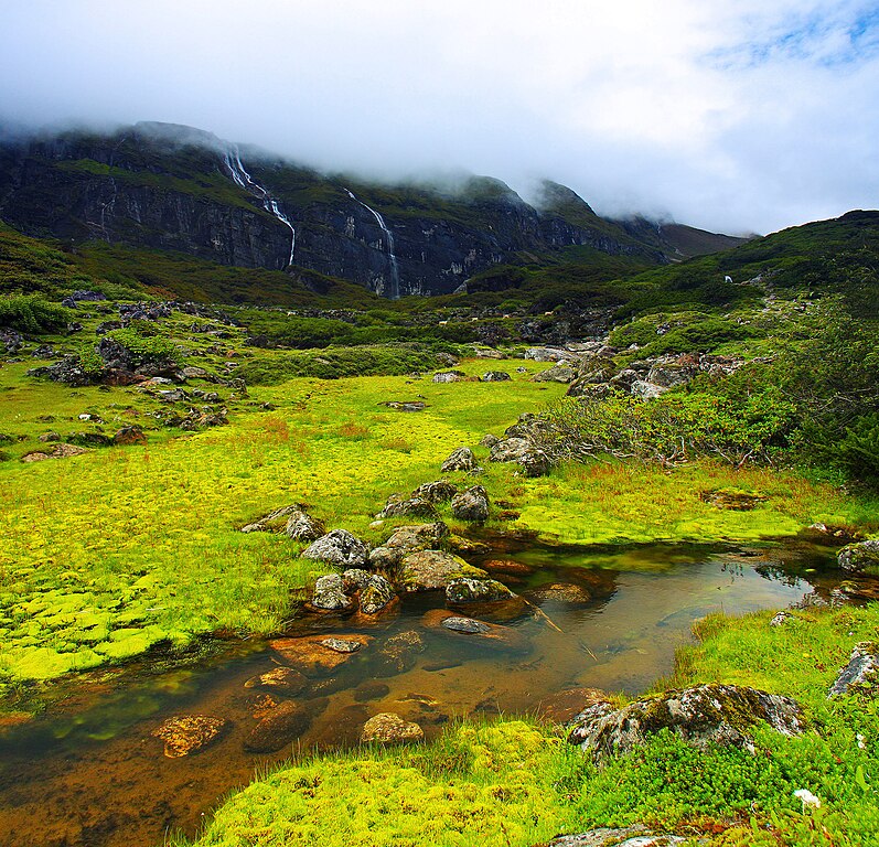
English: This is a place called Ripuk within the Barun Valley. Centuries ago, Barun used to be a glacier here, flowing to the north composing these lush green valleys for today. The cascading waterfalls against the stiff rocks was reflecting the sense of the flowing time and the eternity at the same time. |
| मिति | |
| स्रोत | मेरो आफ्नै कार्य |
| लेखक | Dhilung |
| अरु संस्करणहरू | https://www.flickr.com/photos/dhilung/3919034860/ |
| Camera location | | View this and other nearby images on: OpenStreetMap |
|---|
अनुज्ञा प्राप्त गर्दै
I, the copyright holder of this work, hereby publish it under the following license:
This file is licensed under the Creative Commons Attribution 3.0 Unported license.
- तपाईं स्वतन्त्र हुनुहुन्छ :
- साझेदारी गर्नुहाेस् – रचनालाई कपी, वितरित तथा संचारित गर्नको लागि
- रिमिक्स गर्नको लागि – काम अनुकूलित गर्नको लागि
- निम्नलिखित कारणहरूको अन्तर्गत:
- एट्रिब्युसन – तपाईंले रचनाको श्रेय अनुमतिपत्रकर्ता अथवा लेखकले बताएको माध्यमले दिनु पर्नेछ (तर यस प्रकार हैन, जसमा लागोस् की उ तपाईंलाई अथवा तपाईंको रचनाको प्रयोगलाई समर्थन गर्छन्)।
फाइल इतिहास
मिति/समय मा क्लिक गरेर त्यससमयमा यो फाइल कस्तो थियो भनेर हेर्न सकिन्छ ।
| मिति/समय | छोटो चित्र | आकारहरू | प्रयोगकर्ता | टिप्पणी | |
|---|---|---|---|---|---|
| हालको | ०४:०५, १७ जनवरी २०१० | | १,९८०×१,९०९ (३.३९ मेगाबाइटहरू) | Dhilung | Without watermark removed. GPS info embedded. |
| १२:१६, १९ सेप्टेम्बर २००९ |  | २,१५०×२,०७८ (२.१५ मेगाबाइटहरू) | Dhilung | {{Information |Description={{en|1=This is a place called Ripuk within the Barun Valley. Centuries ago, Barun used to be a glacier here, flowing to the north composing these lush green valleys for today. The cascading waterfalls against the stiff rocks was |
फाइल प्रयोग
यस फाइलमा निम्न 4 पृष्ठहरू जोडिन्छन्:
विश्वव्यापी फाइल प्रयोग
निम्न अन्य विकिहरूमा यस फाइलको प्रयोग:
- bh.wikipedia.org मा उपयोग
- bn.wikipedia.org मा उपयोग
- de.wikipedia.org मा उपयोग
- dty.wikipedia.org मा उपयोग
- en.wikipedia.org मा उपयोग
- es.wikipedia.org मा उपयोग
- fa.wikipedia.org मा उपयोग
- fr.wikipedia.org मा उपयोग
- hi.wikipedia.org मा उपयोग
- it.wikipedia.org मा उपयोग
- lt.wikipedia.org मा उपयोग
- mai.wikipedia.org मा उपयोग
- mk.wikipedia.org मा उपयोग
- ml.wikipedia.org मा उपयोग
- pa.wikipedia.org मा उपयोग
- pnb.wikipedia.org मा उपयोग
- ru.wikipedia.org मा उपयोग
- sat.wikipedia.org मा उपयोग
- sa.wikipedia.org मा उपयोग
- sl.wikipedia.org मा उपयोग
- ta.wikipedia.org मा उपयोग
- th.wikipedia.org मा उपयोग
- tt.wikipedia.org मा उपयोग
- ur.wikipedia.org मा उपयोग
- vi.wikipedia.org मा उपयोग
- www.wikidata.org मा उपयोग