चित्र:Mongols-map.png
यस पूर्व रुपको आकार: ७२२ × ५९९ पिक्सल। अरु संकल्पहरू: २८९ × २४० पिक्सल • ५७८ × ४८० पिक्सल • ९२५ × ७६८ पिक्सल • १,२३४ × १,०२४ पिक्सल • १,८०१ × १,४९५ पिक्सल।
मूल फाइल (१,८०१ × १,४९५ पिक्सेलहरू, फाइल आकार: २.७९ मेगाबाइटहरू, MIME प्रकार: image/png)
| यो विकिमीडिया कमन्सको चित्र हो। त्यहाँ यसको विवरण पृष्ठबाट जानकारी तल देखाइएको छ। कमन्स स्वतन्त्र रूपमा इजाजतपत्र प्राप्त चित्र भण्डार हो। तपाईंले मद्दत गर्न सक्नुहुन्छ। |
सारांश
| वर्णन |
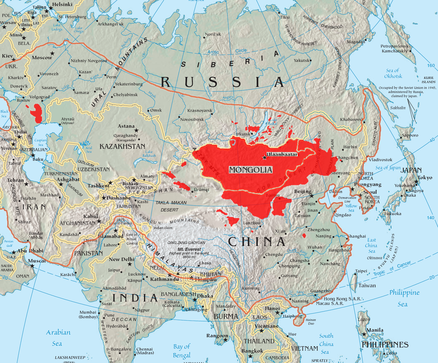
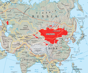
English: A map of the places that Mongol peoples live.
The orange line shows the extent of the Mongol Empire in the late 13th century. The red areas are the places dominated by ethnic Mongols. |
| मिति | |
| स्रोत |
|
| लेखक | Quadell |

|
This linguistic map image could be re-created using vector graphics as an SVG file. This has several advantages; see Commons:Media for cleanup for more information. If an SVG form of this image is available, please upload it and afterwards replace this template with
{{vector version available|new image name}}.
It is recommended to name the SVG file “Mongols-map.svg”—then the template Vector version available (or Vva) does not need the new image name parameter. |
अनुज्ञा प्राप्त गर्दै
I, the copyright holder of this work, hereby publish it under the following licenses:

|
यस दस्तावेजलाई स्वतन्त्र सफ्टवायर फाउन्डेसन द्वारा प्रकाशित जी॰एन॰यू फ्रि डक्यूमेन्टेशन लाइसेन्स को संस्करण 1.2 वा नयाँ (बिना कुनै इन्वेरियेन्ट अनुभाग र पछिल्लो वा पहिलो आवरणका पाठका) को अन्तर्गत कपी, वितरित एवं/अथवा परिवर्तित गर्ने अनुमति प्रदान गरिन्छ । यस लाइसेन्सको एक प्रति जी॰एन॰यू फ्रि डक्यूमेन्टेशन लाइसेन्स नामक अनुभागमा शामिल छ । |
| यो फाइल क्रिएटिभ कमन्स एट्रिब्युसन-सेयर एलाइक ३.० अनपोर्टेड लाइसेन्स अनुसारको अनुमति प्राप्त छ। | ||
| ||
| This licensing tag was added to this file as part of the GFDL licensing update. |
This file is licensed under the Creative Commons Attribution-Share Alike 2.0 Generic license.
- तपाईं स्वतन्त्र हुनुहुन्छ :
- साझेदारी गर्नुहाेस् – रचनालाई कपी, वितरित तथा संचारित गर्नको लागि
- रिमिक्स गर्नको लागि – काम अनुकूलित गर्नको लागि
- निम्नलिखित कारणहरूको अन्तर्गत:
- एट्रिब्युसन – तपाईंले रचनाको श्रेय अनुमतिपत्रकर्ता अथवा लेखकले बताएको माध्यमले दिनु पर्नेछ (तर यस प्रकार हैन, जसमा लागोस् की उ तपाईंलाई अथवा तपाईंको रचनाको प्रयोगलाई समर्थन गर्छन्)।
- शेयर अलाइक – यदि तपाई यस रचनामा कुनै परिवर्तन अथवा संसोधन गर्नुहुन्छ या यसमा आधारित केही रचना गर्नुहुन्छ भने तपाई निष्कर्ष स्वरूप बनेको रचनालाई मात्र यहाँ अथवा यसको समान कुनै अनिमति पत्र अन्तर्गत वितरित गर्न सक्नुहुन्छ।
तपाईँ आफ्नो मनपर्ने इजाजतपत्र रोज्न सक्नुहुन्छ ।
फाइल इतिहास
मिति/समय मा क्लिक गरेर त्यससमयमा यो फाइल कस्तो थियो भनेर हेर्न सकिन्छ ।
| मिति/समय | छोटो चित्र | आकारहरू | प्रयोगकर्ता | टिप्पणी | |
|---|---|---|---|---|---|
| हालको | २०:२२, २९ मे २०२३ | | १,८०१×१,४९५ (२.७९ मेगाबाइटहरू) | Artanisen | High resolution map with the same borders and areas as version 17:34, 16 July 2005 (UTC) |
| ०१:५८, ११ अप्रिल २०२१ |  | ७२८×५२५ (२७९ किलोबाइटहरू) | Fæ | Reverted to version as of 17:34, 16 July 2005 (UTC) Untrusted work of sockpuppets | |
| ०९:२०, १७ जनवरी २०१९ |  | ७२८×५२५ (२९५ किलोबाइटहरू) | Anchuhu | mongol | |
| १६:४१, २२ जुन २०१७ |  | ७२८×५२५ (६३० किलोबाइटहरू) | 일성강 | Reverted to version as of 12:47, 1 June 2017 (UTC) | |
| १४:३९, १७ जुन २०१७ |  | ७२८×५२५ (२७९ किलोबाइटहरू) | Calthinus | Reverted to version as of 17:34, 16 July 2005 (UTC) | |
| १८:३२, १ जुन २०१७ |  | ७२८×५२५ (६३० किलोबाइटहरू) | 일성강 | fixed | |
| २३:१९, १६ जुलाई २००५ |  | ७२८×५२५ (२७९ किलोबाइटहरू) | Hottentot~commonswiki | This is a map of the places that Mongol peoples live. The information is based off of w:en:Image:Mongolsethnic.jpg, and the map I started with is w:en:Image:Asia-map.png. The orange line shows the extent of the Mongol Empire in the late 13th c | |
| १८:५९, १६ जुलाई २००५ |  | ७२८×५२५ (२९७ किलोबाइटहरू) | Quadell | This is a map of the places that Mongol peoples live. The information is based off of [:w:en:Image:Mongolsethnic.jpg]], and the map I started with is w:en:Image:Asia-map.png. The orange line shows the extent of the Mongol Empire in the late 13th ce |
फाइल प्रयोग
यस फाइलमा निम्न पृष्ठ जोडिन्छ:
विश्वव्यापी फाइल प्रयोग
निम्न अन्य विकिहरूमा यस फाइलको प्रयोग:
- af.wikipedia.org मा उपयोग
- an.wikipedia.org मा उपयोग
- ar.wikipedia.org मा उपयोग
- arz.wikipedia.org मा उपयोग
- ast.wikipedia.org मा उपयोग
- azb.wikipedia.org मा उपयोग
- ba.wikipedia.org मा उपयोग
- be-tarask.wikipedia.org मा उपयोग
- be.wikipedia.org मा उपयोग
- bg.wiktionary.org मा उपयोग
- bh.wikipedia.org मा उपयोग
- br.wikipedia.org मा उपयोग
- bs.wikipedia.org मा उपयोग
- ca.wikipedia.org मा उपयोग
- ckb.wikipedia.org मा उपयोग
- cs.wikipedia.org मा उपयोग
- cv.wikipedia.org मा उपयोग
- da.wikipedia.org मा उपयोग
- diq.wikipedia.org मा उपयोग
- dsb.wikipedia.org मा उपयोग
- el.wikipedia.org मा उपयोग
- en.wikipedia.org मा उपयोग
यस फाइलको विश्वव्यापी उपयोगको अधिक जानकारी हेर्नुहोस् ।