चित्र:MH -map A.png

यस पूर्व रुपको आकार: ७४० × ६०० पिक्सल। अरु संकल्पहरू: २९६ × २४० पिक्सल • ५९२ × ४८० पिक्सल • ९५० × ७७० पिक्सल।
मूल फाइल (९५० × ७७० पिक्सेलहरू, फाइल आकार: २० किलोबाइटहरू, MIME प्रकार: image/png)
| यो विकिमीडिया कमन्सको चित्र हो। त्यहाँ यसको विवरण पृष्ठबाट जानकारी तल देखाइएको छ। कमन्स स्वतन्त्र रूपमा इजाजतपत्र प्राप्त चित्र भण्डार हो। तपाईंले मद्दत गर्न सक्नुहुन्छ। |

|
This locator map image could be re-created using vector graphics as an SVG file. This has several advantages; see Commons:Media for cleanup for more information. If an SVG form of this image is available, please upload it and afterwards replace this template with
{{vector version available|new image name}}.
It is recommended to name the SVG file “MH -map A.svg”—then the template Vector version available (or Vva) does not need the new image name parameter. |
सारांश
| वर्णन |
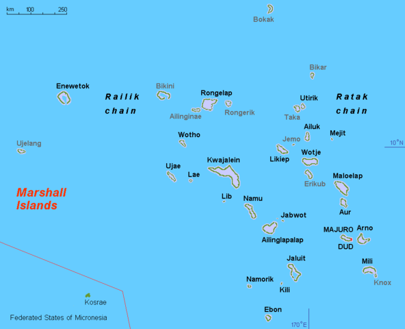
English: Map (rough) Marshall islands, own work composed from various mapreferences |
| मिति | |
| स्रोत | मेरो आफ्नै कार्य |
| लेखक | Hobe / Holger Behr |
| अरु संस्करणहरू |
Derivative works of this file: Operation K Map.jpg
|
अनुज्ञा प्राप्त गर्दै
| I, the copyright holder of this work, release this work into the public domain. This applies worldwide. In some countries this may not be legally possible; if so: I grant anyone the right to use this work for any purpose, without any conditions, unless such conditions are required by law. |
फाइल इतिहास
मिति/समय मा क्लिक गरेर त्यससमयमा यो फाइल कस्तो थियो भनेर हेर्न सकिन्छ ।
| मिति/समय | छोटो चित्र | आकारहरू | प्रयोगकर्ता | टिप्पणी | |
|---|---|---|---|---|---|
| हालको | १९:२९, ११ नोभेम्बर २०१० | | ९५०×७७० (२० किलोबाइटहरू) | Hobe | minor design change, restored origional uploader |
| ०९:४८, १७ सेप्टेम्बर २०१० |  | ९५०×७७५ (३१ किलोबाइटहरू) | Lasunncty | uninhabited islands/atolls in grey | |
| २३:४४, १९ मार्च २००८ |  | ९५०×७७५ (२० किलोबाइटहरू) | Hobe | map (rough) Marshall islands, larger letters Source: self-made, composed from various mapreferences Date 2008-03-13 Author Hobe Category:Maps of the Marshall Islands | |
| ००:१२, १७ मार्च २००८ |  | ९५०×६५० (१७ किलोबाइटहरू) | Hobe | {{Information |Description=map (rough) Marshall islands |Source=self-made, composed from various mapreferences |Date=2008-03-03 |Author= Hobe |Permission= |other_versions= Category:Maps of the Marshall Islands }} Source |
फाइल प्रयोग
यस फाइलमा निम्न पृष्ठ जोडिन्छ:
विश्वव्यापी फाइल प्रयोग
निम्न अन्य विकिहरूमा यस फाइलको प्रयोग:
- af.wikipedia.org मा उपयोग
- ami.wikipedia.org मा उपयोग
- ar.wikipedia.org मा उपयोग
- ast.wikipedia.org मा उपयोग
- ba.wikipedia.org मा उपयोग
- br.wikipedia.org मा उपयोग
- ca.wikipedia.org मा उपयोग
- da.wikipedia.org मा उपयोग
- el.wikipedia.org मा उपयोग
- en.wikipedia.org मा उपयोग
- en.wiktionary.org मा उपयोग
- es.wikipedia.org मा उपयोग
- eu.wikipedia.org मा उपयोग
- fa.wikipedia.org मा उपयोग
- fi.wikipedia.org मा उपयोग
- fr.wikipedia.org मा उपयोग
- gl.wikipedia.org मा उपयोग
यस फाइलको विश्वव्यापी उपयोगको अधिक जानकारी हेर्नुहोस् ।