चित्र:Kerala locator map.svg

Size of this PNG preview of this SVG file: ४९४ × ६०० पिक्सल. अरु संकल्पहरू: १९८ × २४० पिक्सल • ३९५ × ४८० पिक्सल • ६३२ × ७६८ पिक्सल • ८४३ × १,०२४ पिक्सल • १,६८७ × २,०४८ पिक्सल • १,३४० × १,६२७ पिक्सल।
मूल फाइल (SVG फाइल,साधारण १,३४० × १,६२७ पिक्सेलहरु, फाइल आकार: १५१ किलोबाइटहरू)
| यो विकिमीडिया कमन्सको चित्र हो। त्यहाँ यसको विवरण पृष्ठबाट जानकारी तल देखाइएको छ। कमन्स स्वतन्त्र रूपमा इजाजतपत्र प्राप्त चित्र भण्डार हो। तपाईंले मद्दत गर्न सक्नुहुन्छ। |
| शीर्षक |
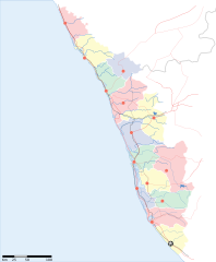
Kerala locator map |
||
| Description |
Locator map for the state of w:Kerala |
||
| मिति | |||
| स्रोत |
मेरो आफ्नै कार्य |
||
| रचनाकार |
|
||
| अनुमति (यो फाइल पुनप्रयोग गर्न) |
I, the copyright holder of this work, hereby publish it under the following license: यो फाइल क्रिएटिभ कमन्स एट्रिब्युसन-सेयर एलाइक ३.० अनपोर्टेड लाइसेन्स अनुसारको अनुमति प्राप्त छ।
|
||
| Geotemporal data | |||
| Date depicted | second half of 20 century र 21 century | ||
| Georeferencing | If inappropriate please set warp_status = skip to hide. | ||
| Archival data | |||
| टिप्पणी | Part of WikiProject India Maps | ||
फाइल इतिहास
मिति/समय मा क्लिक गरेर त्यससमयमा यो फाइल कस्तो थियो भनेर हेर्न सकिन्छ ।
| मिति/समय | छोटो चित्र | आकारहरू | प्रयोगकर्ता | टिप्पणी | |
|---|---|---|---|---|---|
| हालको | २०:३८, १३ अप्रिल २००७ | | १,३४०×१,६२७ (१५१ किलोबाइटहरू) | Planemad | correcting crop |
| २०:३७, १३ अप्रिल २००७ |  | १,५९१×१,९७५ (१५२ किलोबाइटहरू) | Planemad | ||
| २३:५४, ९ अप्रिल २००७ |  | १,३२३×१,६०७ (६८ किलोबाइटहरू) | Planemad | {{WikiProject_India_Maps |Title=Kerala locator map |Description=Locator map for the state of [w:Kerala]] |Source= [http://keralapolice.org/map/keralamap.html Kerala Police - Map of Kerala], |Date=April 2007 |Author=w:user:Planemad }} [[Category:Wiki |
फाइल प्रयोग
यस फाइलमा निम्न पृष्ठ जोडिन्छ:
विश्वव्यापी फाइल प्रयोग
निम्न अन्य विकिहरूमा यस फाइलको प्रयोग:
- awa.wikipedia.org मा उपयोग
- bo.wikipedia.org मा उपयोग
- de.wikipedia.org मा उपयोग
- dv.wikipedia.org मा उपयोग
- en.wikipedia.org मा उपयोग
- es.wikipedia.org मा उपयोग
- fa.wikipedia.org मा उपयोग
- gd.wikipedia.org मा उपयोग
- gu.wikipedia.org मा उपयोग
- hi.wikipedia.org मा उपयोग
- कोल्लम जिला
- मुन्नार
- मालाबार
- कोवलम
- पुथूर
- कुमारकोम
- साँचा:केरल के लोकसभा निर्वाचन क्षेत्र
- मलप्पुरम लोक सभा निर्वाचन क्षेत्र
- आलप्पुष़ा लोक सभा निर्वाचन क्षेत्र
- आलत्तूर लोक सभा निर्वाचन क्षेत्र
- आट्टिंगल लोक सभा निर्वाचन क्षेत्र
- चालकुडी लोक सभा निर्वाचन क्षेत्र
- एर्णाकुलम लोक सभा निर्वाचन क्षेत्र
- इदुक्की लोक सभा निर्वाचन क्षेत्र
- कन्नूर लोक सभा निर्वाचन क्षेत्र
- कासरगोड लोक सभा निर्वाचन क्षेत्र
- कोल्लम लोक सभा निर्वाचन क्षेत्र
- कोट्टयम लोक सभा निर्वाचन क्षेत्र
- कोष़िक्कोड लोक सभा निर्वाचन क्षेत्र
- मावेलिक्करा लोक सभा निर्वाचन क्षेत्र
- वयनाड लोक सभा निर्वाचन क्षेत्र
- पालक्काड लोक सभा निर्वाचन क्षेत्र
- पत्तनमतिट्टा लोक सभा निर्वाचन क्षेत्र
- पोन्नानी लोक सभा निर्वाचन क्षेत्र
- तिरुवनन्तपुरम लोक सभा निर्वाचन क्षेत्र
- त्रिश्शूर लोक सभा निर्वाचन क्षेत्र
- वडकरा लोक सभा निर्वाचन क्षेत्र
- केरल के मुख्यमंत्रियों की सूची
- incubator.wikimedia.org मा उपयोग
- ka.wikipedia.org मा उपयोग
- mai.wikipedia.org मा उपयोग
- ml.wikipedia.org मा उपयोग
यस फाइलको विश्वव्यापी उपयोगको अधिक जानकारी हेर्नुहोस् ।