चित्र:Indus river.svg

Size of this PNG preview of this SVG file: ५५५ × ६०० पिक्सल. अरु संकल्पहरू: २२२ × २४० पिक्सल • ४४४ × ४८० पिक्सल • ७११ × ७६८ पिक्सल • ९४८ × १,०२४ पिक्सल • १,८९५ × २,०४८ पिक्सल • २,३०९ × २,४९५ पिक्सल।
मूल फाइल (SVG फाइल,साधारण २,३०९ × २,४९५ पिक्सेलहरु, फाइल आकार: १७२ किलोबाइटहरू)
| यो विकिमीडिया कमन्सको चित्र हो। त्यहाँ यसको विवरण पृष्ठबाट जानकारी तल देखाइएको छ। कमन्स स्वतन्त्र रूपमा इजाजतपत्र प्राप्त चित्र भण्डार हो। तपाईंले मद्दत गर्न सक्नुहुन्छ। |
https://iasbaba.com/wp-content/uploads/2023/01/Indus-Waters-Treaty.png.webp
सारांश
| वर्णन |
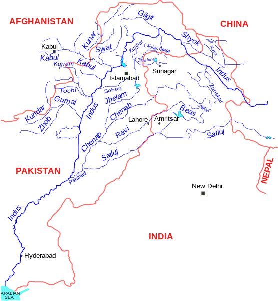
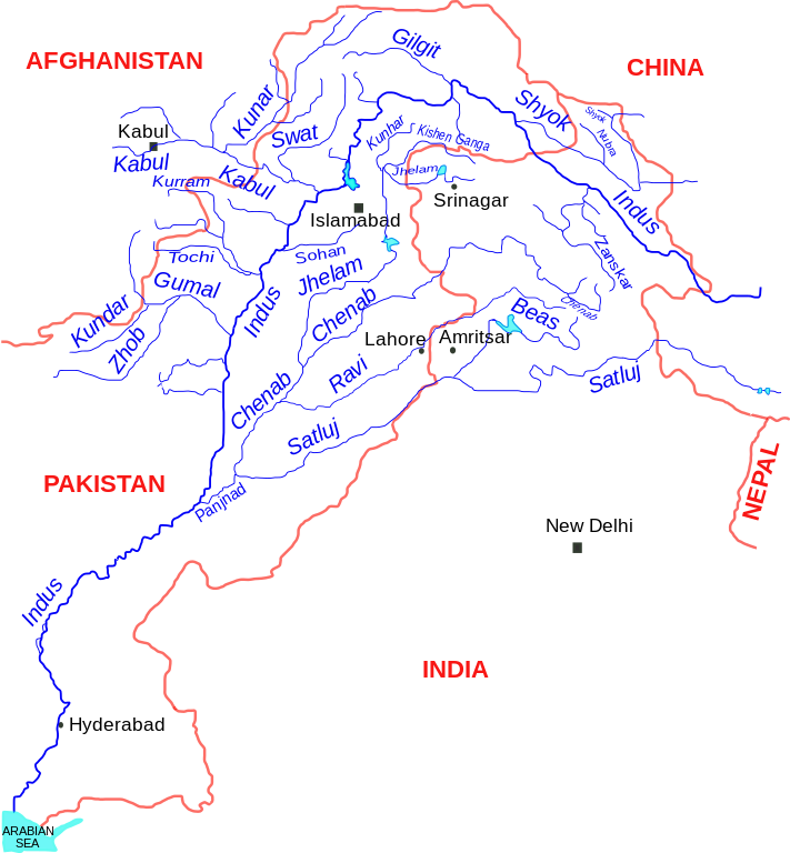
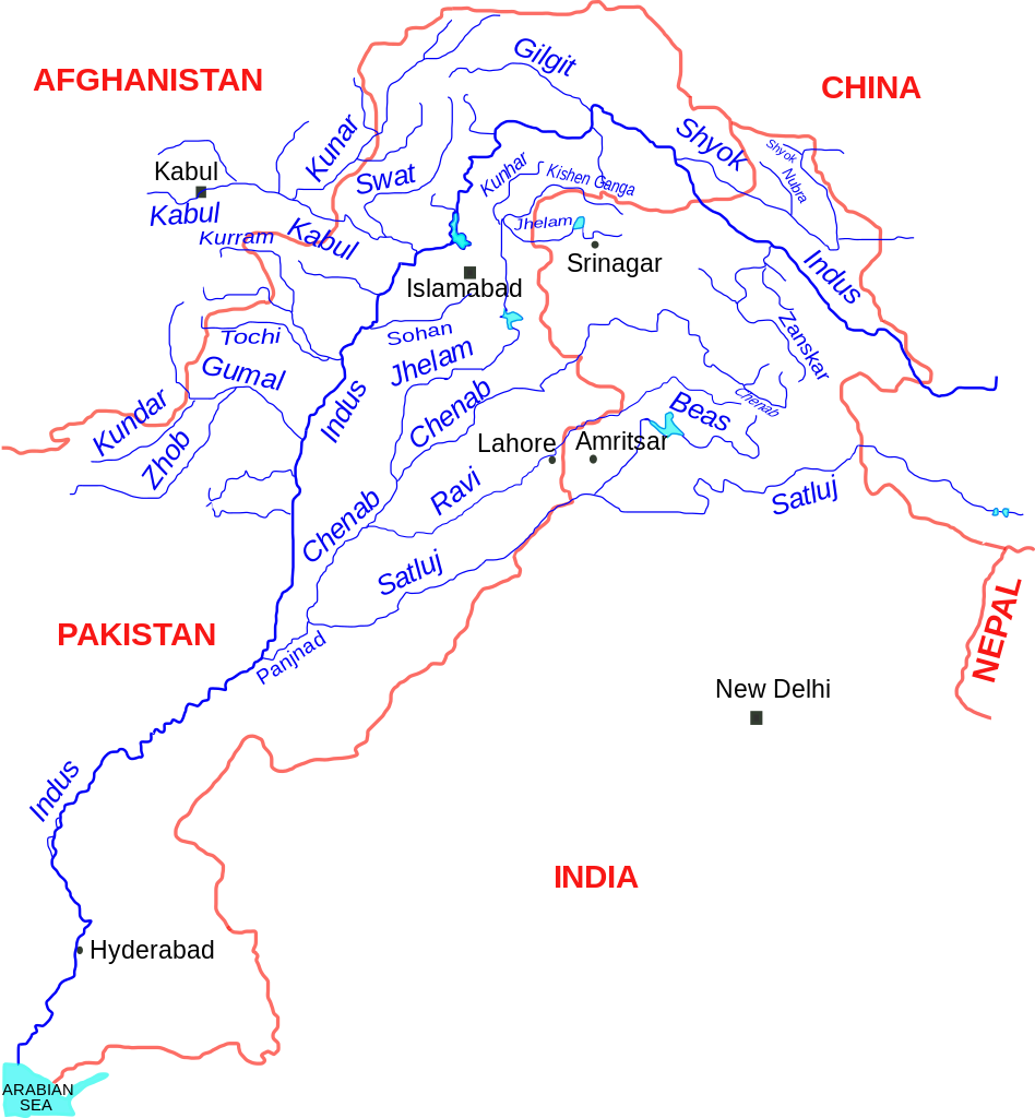
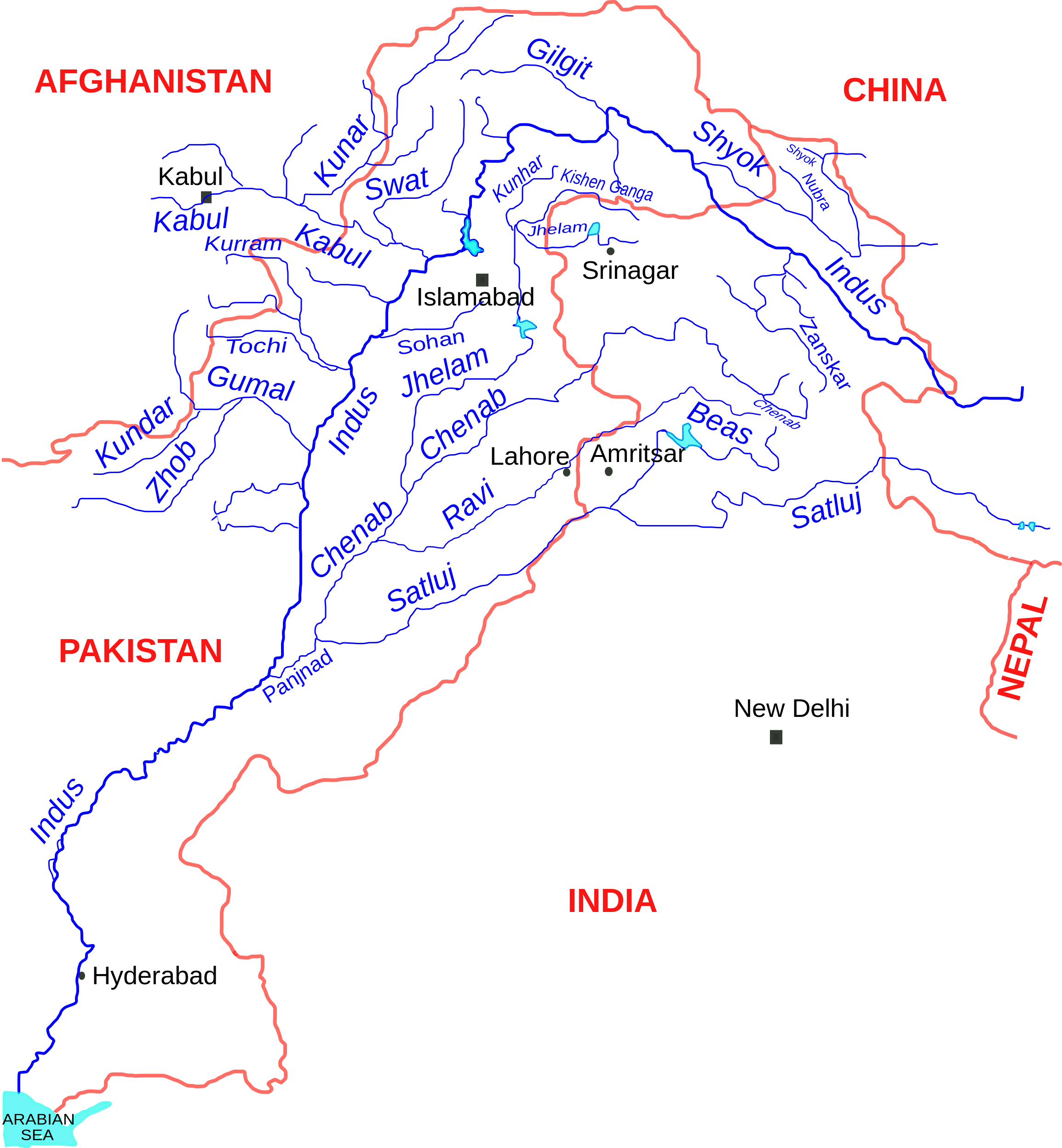
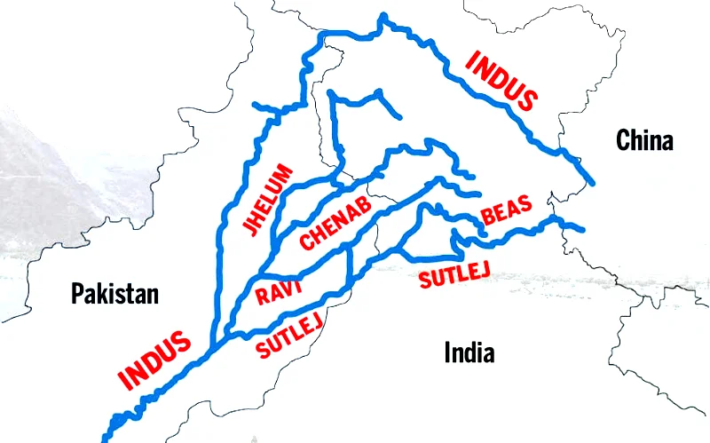
English: Indus river and tributaries, data based on The Times Atlas of the world (Family edition) |
| मिति | |
| स्रोत | मेरो आफ्नै कार्य |
| लेखक | Kmhkmh |
अनुज्ञा प्राप्त गर्दै
I, the copyright holder of this work, hereby publish it under the following license:
This file is licensed under the Creative Commons Attribution 3.0 Unported license.
- तपाईं स्वतन्त्र हुनुहुन्छ :
- साझेदारी गर्नुहाेस् – रचनालाई कपी, वितरित तथा संचारित गर्नको लागि
- रिमिक्स गर्नको लागि – काम अनुकूलित गर्नको लागि
- निम्नलिखित कारणहरूको अन्तर्गत:
- एट्रिब्युसन – तपाईंले रचनाको श्रेय अनुमतिपत्रकर्ता अथवा लेखकले बताएको माध्यमले दिनु पर्नेछ (तर यस प्रकार हैन, जसमा लागोस् की उ तपाईंलाई अथवा तपाईंको रचनाको प्रयोगलाई समर्थन गर्छन्)।
| Warning! According to Indian law, it is illegal to produce maps that in the view of the Indian government, misrepresent Indian territories by showing areas the Indian government claims ownership of but does not control as not belonging to India or as being contested. |
फाइल इतिहास
मिति/समय मा क्लिक गरेर त्यससमयमा यो फाइल कस्तो थियो भनेर हेर्न सकिन्छ ।
| मिति/समय | छोटो चित्र | आकारहरू | प्रयोगकर्ता | टिप्पणी | |
|---|---|---|---|---|---|
| हालको | १७:०४, ११ सेप्टेम्बर २०१७ | | २,३०९×२,४९५ (१७२ किलोबाइटहरू) | Kmhkmh | minor tweaks |
| ०१:४९, २५ जुलाई २०१५ |  | २,३०९×२,४९५ (१७३ किलोबाइटहरू) | Kmhkmh | the the modification is not correct and only depicting the _temporary_ flow of floodwaters | |
| २३:४०, २४ अप्रिल २०१५ |  | २,३०९×२,४९५ (१८२ किलोबाइटहरू) | RaviC | Rough redrawing of new southern pathway found. Source: http://indiatoday.intoday.in/story/indus-river-re-enters-india/1/158976.html | |
| १६:०८, १ जुन २००९ |  | २,३०९×२,४९५ (१७३ किलोबाइटहरू) | Kmhkmh | few details added | |
| १६:१७, ३० मे २००९ |  | २,२८५×२,४९५ (१५१ किलोबाइटहरू) | Kmhkmh | few detailes added | |
| ०३:५८, ३० मे २००९ |  | २,२८५×२,४९५ (१२१ किलोबाइटहरू) | Kmhkmh | {{Information |Description={{en|1=Indus river and tributaries}} |Source=Own work by uploader |Author=Kmhkmh |Date=2009-5-29 |Permission= |other_versions= }} <!--{{ImageUpload|full}}--> |
फाइल प्रयोग
यस फाइलमा निम्न पृष्ठ जोडिन्छ:
विश्वव्यापी फाइल प्रयोग
निम्न अन्य विकिहरूमा यस फाइलको प्रयोग:
- af.wikipedia.org मा उपयोग
- als.wikipedia.org मा उपयोग
- am.wikipedia.org मा उपयोग
- ar.wikipedia.org मा उपयोग
- ast.wikipedia.org मा उपयोग
- as.wikipedia.org मा उपयोग
- awa.wikipedia.org मा उपयोग
- azb.wikipedia.org मा उपयोग
- ba.wikipedia.org मा उपयोग
- be.wikipedia.org मा उपयोग
- bg.wikipedia.org मा उपयोग
- bh.wikipedia.org मा उपयोग
- bn.wikipedia.org मा उपयोग
- ca.wikipedia.org मा उपयोग
- ceb.wikipedia.org मा उपयोग
- ce.wikipedia.org मा उपयोग
- ckb.wikipedia.org मा उपयोग
- cs.wikipedia.org मा उपयोग
- da.wikipedia.org मा उपयोग
यस फाइलको विश्वव्यापी उपयोगको अधिक जानकारी हेर्नुहोस् ।