चित्र:India1765and1805b.jpg

यस पूर्व रुपको आकार: ७७४ × ५९९ पिक्सल। अरु संकल्पहरू: ३१० × २४० पिक्सल • ६२० × ४८० पिक्सल • ९९२ × ७६८ पिक्सल • १,२२७ × ९५० पिक्सल।
मूल फाइल (१,२२७ × ९५० पिक्सेलहरू, फाइल आकार: ३०७ किलोबाइटहरू, MIME प्रकार: image/jpeg)
| यो विकिमीडिया कमन्सको चित्र हो। त्यहाँ यसको विवरण पृष्ठबाट जानकारी तल देखाइएको छ। कमन्स स्वतन्त्र रूपमा इजाजतपत्र प्राप्त चित्र भण्डार हो। तपाईंले मद्दत गर्न सक्नुहुन्छ। |
सारांश
| वर्णन |
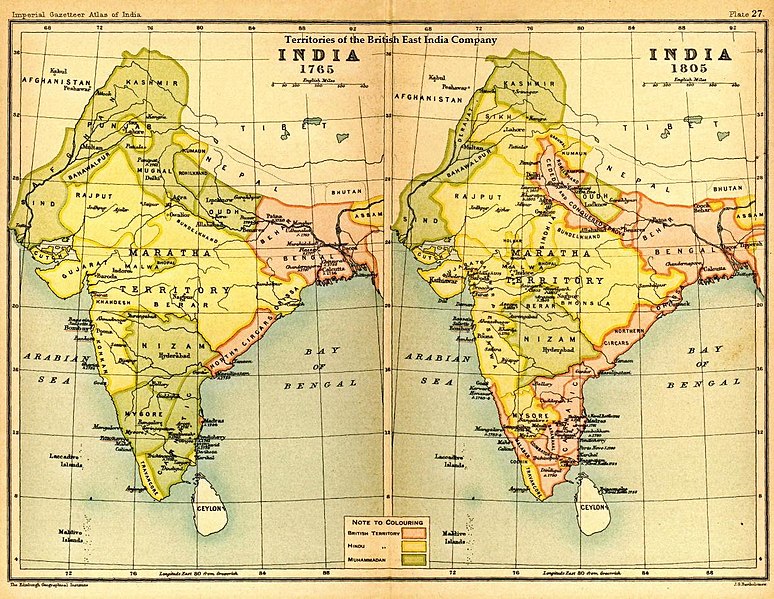
English: Map of India under the British East India Company, comparing 1765 and 1805 |
|||||
| मिति | ||||||
| स्रोत | Imperial Gazetteer of India, Secretary of State for India, OUP, 1907. Scanned from personal copy Fowler&fowler, 22:32, 29 August 2007 (UTC) | |||||
| लेखक | Edinburgh Geographical Institute. | |||||
| अनुमति (यो फाइल पुनप्रयोग गर्न) |
|

Original upload log
The original description page was here. All following user names refer to en.wikipedia.
- 2010-04-18 16:17 Beao 1227×950× (314652 bytes) Removed watermark.
- 2007-08-29 22:32 Fowler&fowler 1227×950× (284253 bytes) == Summary == Image of map of India under the British East India Company from Imperial Gazetteer of India,Oxford University Press, 1907. Scanned and reduced from personal copy by ~~~~ {{PD-old-70}} ==Licensing== {{PD-US-1923-abroad}}
फाइल इतिहास
मिति/समय मा क्लिक गरेर त्यससमयमा यो फाइल कस्तो थियो भनेर हेर्न सकिन्छ ।
| मिति/समय | छोटो चित्र | आकारहरू | प्रयोगकर्ता | टिप्पणी | |
|---|---|---|---|---|---|
| हालको | ०३:५३, ६ अगस्ट २०१७ | | १,२२७×९५० (३०७ किलोबाइटहरू) | OgreBot | (BOT): Reverting to most recent version before archival |
| ०३:५३, ६ अगस्ट २०१७ |  | १,२२७×९५० (२७८ किलोबाइटहरू) | OgreBot | (BOT): Uploading old version of file from en.wikipedia; originally uploaded on 2007-08-29 22:32:42 by Fowler&fowler | |
| २१:५१, ३० अप्रिल २०१३ |  | १,२२७×९५० (३०७ किलोबाइटहरू) | Gz deleted | {{Information |Description=Indian map |Source=en wiki |Date=unknown |Author=unknown |Permission={{GFDL-user-w|||User:Fowler&fowler}} |other_versions= }} |
फाइल प्रयोग
यस फाइलमा निम्न 2 पृष्ठहरू जोडिन्छन्:
विश्वव्यापी फाइल प्रयोग
निम्न अन्य विकिहरूमा यस फाइलको प्रयोग:
- ar.wikipedia.org मा उपयोग
- azb.wikipedia.org मा उपयोग
- cs.wikipedia.org मा उपयोग
- de.wikiversity.org मा उपयोग
- el.wikipedia.org मा उपयोग
- en.wikipedia.org मा उपयोग
- es.wikipedia.org मा उपयोग
- fa.wikipedia.org मा उपयोग
- fr.wikipedia.org मा उपयोग
- incubator.wikimedia.org मा उपयोग
- pa.wikipedia.org मा उपयोग
- pnb.wikipedia.org मा उपयोग
- pt.wikipedia.org मा उपयोग
- sl.wikipedia.org मा उपयोग
- ta.wikipedia.org मा उपयोग
- te.wikipedia.org मा उपयोग
- th.wikipedia.org मा उपयोग
- ur.wikipedia.org मा उपयोग
- www.wikidata.org मा उपयोग