चित्र:IBCAO betamap.jpg
यस पूर्व रुपको आकार: ५२६ × ५९९ पिक्सल। अरु संकल्पहरू: २११ × २४० पिक्सल • ४२१ × ४८० पिक्सल • ७६२ × ८६८ पिक्सल।
मूल फाइल (७६२ × ८६८ पिक्सेलहरू, फाइल आकार: ७१० किलोबाइटहरू, MIME प्रकार: image/jpeg)
| यो विकिमीडिया कमन्सको चित्र हो। त्यहाँ यसको विवरण पृष्ठबाट जानकारी तल देखाइएको छ। कमन्स स्वतन्त्र रूपमा इजाजतपत्र प्राप्त चित्र भण्डार हो। तपाईंले मद्दत गर्न सक्नुहुन्छ। |
| Description |
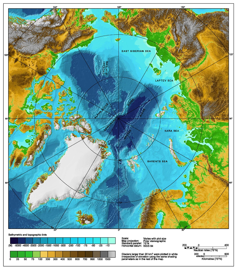
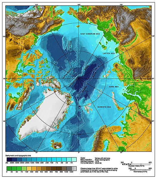
Bathymetric map of the Arctic Ocean |
|||||||||
| स्रोत | http://www.ngdc.noaa.gov/mgg/image/IBCAO_betamap.jpg | |||||||||
| अनुमति (यो फाइल पुनप्रयोग गर्न) |
|
|||||||||
| Geotemporal data | ||||||||||
| Bounding box |
|
|||||||||
| Georeferencing | ||||||||||
| अरु संस्करणहरू |
Derivative works of this file: |
|||||||||
फाइल इतिहास
मिति/समय मा क्लिक गरेर त्यससमयमा यो फाइल कस्तो थियो भनेर हेर्न सकिन्छ ।
| मिति/समय | छोटो चित्र | आकारहरू | प्रयोगकर्ता | टिप्पणी | |
|---|---|---|---|---|---|
| हालको | ०६:१४, २ अगस्ट २००७ | | ७६२×८६८ (७१० किलोबाइटहरू) | Mikkalai | Source: http://www.ngdc.noaa.gov/mgg/image/IBCAO_betamap.jpg Bathymetric map of the w:Arctic Ocean |
फाइल प्रयोग
यस फाइलमा निम्न पृष्ठ जोडिन्छ:
विश्वव्यापी फाइल प्रयोग
निम्न अन्य विकिहरूमा यस फाइलको प्रयोग:
- af.wikipedia.org मा उपयोग
- ar.wikipedia.org मा उपयोग
- ary.wikipedia.org मा उपयोग
- ast.wikipedia.org मा उपयोग
- avk.wikipedia.org मा उपयोग
- azb.wikipedia.org मा उपयोग
- bcl.wikipedia.org मा उपयोग
- be.wikipedia.org मा उपयोग
- bg.wikipedia.org मा उपयोग
- bh.wikipedia.org मा उपयोग
- bn.wikipedia.org मा उपयोग
- bxr.wikipedia.org मा उपयोग
- ca.wikipedia.org मा उपयोग
- ceb.wikipedia.org मा उपयोग
- chr.wikipedia.org मा उपयोग
- co.wikipedia.org मा उपयोग
- crh.wikipedia.org मा उपयोग
- cs.wikipedia.org मा उपयोग
- da.wikipedia.org मा उपयोग
- de.wikipedia.org मा उपयोग
- dty.wikipedia.org मा उपयोग
- en.wikipedia.org मा उपयोग
- Talk:Lomonosov Ridge
- Territorial claims in the Arctic
- Arktika 2007
- Portal:Maps/Maps/Geographic
- Portal:Maps/Maps/Geographic/2
- Arctic Ocean
- User:Wiki User 68/My Portal
- User:Wiki User 68/My Portal/Selected geography/1
- List of Russian explorers
- Wikipedia:Reference desk/Archives/Science/2015 May 29
- User:Joelton Ivson/Gather lists/24441 – Conflitos internacionais
- Portal:Oceans
- en.wikinews.org मा उपयोग
- en.wikiversity.org मा उपयोग
- eo.wikipedia.org मा उपयोग
- es.wikipedia.org मा उपयोग
यस फाइलको विश्वव्यापी उपयोगको अधिक जानकारी हेर्नुहोस् ।