मूल फाइल(SVG फाइल,साधारण ६५५ × ५७० पिक्सेलहरु, फाइल आकार: १८३ किलोबाइटहरू)

 
W3C-validity not checked.

सारांश

वर्णन

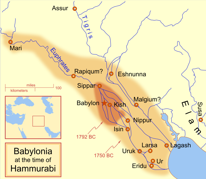
A locator map of Hammurabi's Babylonia, showing the Babylonian territory upon his ascension in 1792 BC and upon his death in 1750 BC. The river courses and coastline are those of that time period -- in general, they are not the modern rivers or coastlines. This is a Mercator projection, with north in its usual position

There is some question to what degree the cities of Nineveh, Tuttul, and Assur were under Babylonian authority. While in his introduction to his code of laws, Hammurabi claims lordship over these cities, Roaf does not include any of these in his map, upon which this map is based, and Chevalas states that "Assur and Nineveh were held for a very few years" (p. 155). Therefore, I have not included them as under Hammurabi's control in 1750 BC.
मिति
स्रोत मेरो आफ्नै कार्य
लेखक MapMaster
अरु संस्करणहरू

[सम्पादन गर्नुहोस्]

See also

References

  • Bjorklund, Oddvar; Holmboe, Haakon; Rohr, Anders (1970) Historical Atlas of the World, Barnes & Noble, NY, SBN: 389-00253-4.
  • Chavalas, Mark W.; K. Lawson Younger (2003) Mesopotamia and the Bible, Continuum International Publishing Group, ISBN 978-0567082312.
  • Hammond World Atlas Corporation (2007) Historical World Atlas, ISBN 9-780843-71391-6
  • Roaf, M. (1990) Cultural Atlas of Mesopotamia and the ancient Near East, Oxford: Facts on File. (In general, the basis for the ancient river courses and ancient coastline).
  • Van De Mieroop, Marc (2005). King Hammurabi of Babylon: A Biography. Blackwell Publishing. ISBN 1405126604

अनुज्ञा प्राप्त गर्दै

I, the copyright holder of this work, hereby publish it under the following licenses:
GNU head यस दस्तावेजलाई स्वतन्त्र सफ्टवायर फाउन्डेसन द्वारा प्रकाशित जी॰एन॰यू फ्रि डक्यूमेन्टेशन लाइसेन्स को संस्करण 1.2 वा नयाँ (बिना कुनै इन्वेरियेन्ट अनुभाग र पछिल्लो वा पहिलो आवरणका पाठका) को अन्तर्गत कपी, वितरित एवं/अथवा परिवर्तित गर्ने अनुमति प्रदान गरिन्छ । यस लाइसेन्सको एक प्रति जी॰एन॰यू फ्रि डक्यूमेन्टेशन लाइसेन्स नामक अनुभागमा शामिल छ ।
w:en:Creative Commons
एट्रिब्युसन शेयर अलाइक
This file is licensed under the Creative Commons Attribution-Share Alike 4.0 International, 3.0 Unported, 2.5 Generic, 2.0 Generic and 1.0 Generic license.
तपाईं स्वतन्त्र हुनुहुन्छ :
  • साझेदारी गर्नुहाेस् – रचनालाई कपी, वितरित तथा संचारित गर्नको लागि
  • रिमिक्स गर्नको लागि – काम अनुकूलित गर्नको लागि
निम्नलिखित कारणहरूको अन्तर्गत:
  • एट्रिब्युसन – तपाईंले रचनाको श्रेय अनुमतिपत्रकर्ता अथवा लेखकले बताएको माध्यमले दिनु पर्नेछ (तर यस प्रकार हैन, जसमा लागोस् की उ तपाईंलाई अथवा तपाईंको रचनाको प्रयोगलाई समर्थन गर्छन्)।
  • शेयर अलाइक – यदि तपाई यस रचनामा कुनै परिवर्तन अथवा संसोधन गर्नुहुन्छ या यसमा आधारित केही रचना गर्नुहुन्छ भने तपाई निष्कर्ष स्वरूप बनेको रचनालाई मात्र यहाँ अथवा यसको समान कुनै अनिमति पत्र अन्तर्गत वितरित गर्न सक्नुहुन्छ।
तपाईँ आफ्नो मनपर्ने इजाजतपत्र रोज्न सक्नुहुन्छ ।

Captions

Add a one-line explanation of what this file represents
Babylonian

Items portrayed in this file

जनाउँछ

some value

Wikimedia username अङ्ग्रेजी: MapMaster
object has role अङ्ग्रेजी: photographer अङ्ग्रेजी
author name string अङ्ग्रेजी: MapMaster

copyright status अङ्ग्रेजी

copyrighted अङ्ग्रेजी

१८ फेब्रुअरी 2008

source of file अङ्ग्रेजी

original creation by uploader अङ्ग्रेजी

MIME type अङ्ग्रेजी

image/svg+xml

फाइल इतिहास

मिति/समय मा क्लिक गरेर त्यससमयमा यो फाइल कस्तो थियो भनेर हेर्न सकिन्छ ।

(अन्तिमपहिलो) हेर्नुहोस् (नयाँ १०) (१०२०५०१००२५०५००)
मिति/समयछोटो चित्रआकारहरूप्रयोगकर्ताटिप्पणी
हालको१४:५९, २१ अप्रिल २०१३छोटो चित्र १४:५९, २१ अप्रिल २०१३ संस्करणको रुपमा६५५×५७० (१८३ किलोबाइटहरू)CitypeekCleanup of file. Valid SVG now.
००:५१, २८ अप्रिल २०१०छोटो चित्र ००:५१, २८ अप्रिल २०१० संस्करणको रुपमा६५५×५७० (१६८ किलोबाइटहरू)DieBucheremoved border
२०:५०, ३० जुलाई २००९छोटो चित्र २०:५०, ३० जुलाई २००९ संस्करणको रुपमा६६१×५८० (३१७ किलोबाइटहरू)Amit6Some nodes changed.
०५:०९, ४ मार्च २००८छोटो चित्र ०५:०९, ४ मार्च २००८ संस्करणको रुपमा६६१×५८० (१६३ किलोबाइटहरू)MapMasterAdded city-state, moved Sippar, minor other changes based on recent Kassite map
२१:५१, २३ फेब्रुअरी २००८छोटो चित्र २१:५१, २३ फेब्रुअरी २००८ संस्करणको रुपमा६६१×५८० (१६१ किलोबाइटहरू)MapMasterAdded 1 city, added name for 1 city
०९:१४, २१ फेब्रुअरी २००८छोटो चित्र ०९:१४, २१ फेब्रुअरी २००८ संस्करणको रुपमा६६१×५८० (१५९ किलोबाइटहरू)MapMaster"blurred" the territory outlines
०५:१०, २१ फेब्रुअरी २००८छोटो चित्र ०५:१०, २१ फेब्रुअरी २००८ संस्करणको रुपमा६६१×५८० (१५५ किलोबाइटहरू)MapMasterChanges made based on info from ''Mesopotamia and the Bible''
०७:४८, १९ फेब्रुअरी २००८छोटो चित्र ०७:४८, १९ फेब्रुअरी २००८ संस्करणको रुपमा६६३×५८० (१५६ किलोबाइटहरू)MapMasterFixed an error on my part
०२:५७, १९ फेब्रुअरी २००८छोटो चित्र ०२:५७, १९ फेब्रुअरी २००८ संस्करणको रुपमा३३२×२९२ (१५६ किलोबाइटहरू)MapMastersome minor edits
०१:०४, १९ फेब्रुअरी २००८छोटो चित्र ०१:०४, १९ फेब्रुअरी २००८ संस्करणको रुपमा३३२×२९३ (१५४ किलोबाइटहरू)MapMasterremoved unrenderable bmp
(अन्तिमपहिलो) हेर्नुहोस् (नयाँ १०) (१०२०५०१००२५०५००)

यस फाइलमा निम्न 2 पृष्ठहरू जोडिन्छन्:

विश्वव्यापी फाइल प्रयोग

निम्न अन्य विकिहरूमा यस फाइलको प्रयोग:

यस फाइलको विश्वव्यापी उपयोगको अधिक जानकारी हेर्नुहोस् ।

मेटाडाटा