चित्र:Gray Wolf Distribution.gif
यस पूर्व रुपको आकार: ८०० × २३८ पिक्सल। अरु संकल्पहरू: ३२० × ९५ पिक्सल • १,१६८ × ३४७ पिक्सल।
मूल फाइल (१,१६८ × ३४७ पिक्सेलहरू, फाइल आकार: १७ किलोबाइटहरू, MIME प्रकार: image/gif)
| यो विकिमीडिया कमन्सको चित्र हो। त्यहाँ यसको विवरण पृष्ठबाट जानकारी तल देखाइएको छ। कमन्स स्वतन्त्र रूपमा इजाजतपत्र प्राप्त चित्र भण्डार हो। तपाईंले मद्दत गर्न सक्नुहुन्छ। |
सारांश
| वर्णन |
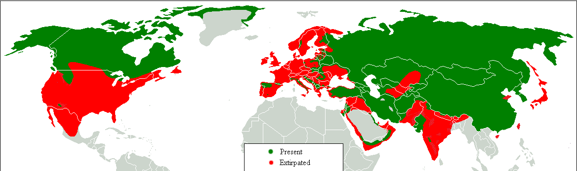
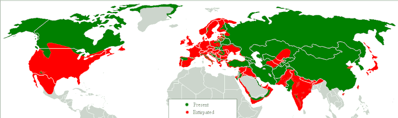
Dansk: Udbredelseskort. Grøn: idag, rød: historisk. English: Range map. Green, present; red, former. Հայերեն: Գայլերի բնակեցման քարտեզ, կանաչ գույնով պատկերված է ներկա արեալը, իսկ կարմիր գույնով՝ պատմական: |
| मिति | |
| स्रोत | Transferred from en.wikipedia to Commons.;. |
| लेखक | Tommyknocker at अङ्ग्रेजी विकिपीडिया |

|
This biogeographical map image could be re-created using vector graphics as an SVG file. This has several advantages; see Commons:Media for cleanup for more information. If an SVG form of this image is available, please upload it and afterwards replace this template with
{{vector version available|new image name}}.
It is recommended to name the SVG file “Gray Wolf Distribution.svg”—then the template Vector version available (or Vva) does not need the new image name parameter. |
अनुज्ञा प्राप्त गर्दै
| This work has been released into the public domain by its author, Tommyknocker at अङ्ग्रेजी विकिपीडिया. This applies worldwide. In some countries this may not be legally possible; if so: Tommyknocker grants anyone the right to use this work for any purpose, without any conditions, unless such conditions are required by law. |
Original upload log
Original description page is/was here(All user names refer to en.wikipedia)
- 2007-03-03 12:04 Tommyknocker 1168×347×8 (16467 bytes)
| Annotations | This image is annotated: View the annotations at Commons |
फाइल इतिहास
मिति/समय मा क्लिक गरेर त्यससमयमा यो फाइल कस्तो थियो भनेर हेर्न सकिन्छ ।
| मिति/समय | छोटो चित्र | आकारहरू | प्रयोगकर्ता | टिप्पणी | |
|---|---|---|---|---|---|
| हालको | १५:०३, १७ फेब्रुअरी २०१८ | १,१६८×३४७ (१७ किलोबाइटहरू) | William Harris | Refer discussion page - North America | |
| १४:५३, १६ फेब्रुअरी २०१८ | १,१६८×३४७ (१७ किलोबाइटहरू) | William Harris | Refer Discussion page - Caucasus, Turkey and Kyrgyzstan | ||
| १२:१४, १५ फेब्रुअरी २०१८ | १,१६८×३४७ (१७ किलोबाइटहरू) | William Harris | Refer Discussion page - Iran, Pakistan and India | ||
| ११:४३, १४ फेब्रुअरी २०१८ | १,१६८×३४७ (१६ किलोबाइटहरू) | William Harris | Refer Discussion page - India, Nepal, Bhutan, China | ||
| १७:२६, १३ फेब्रुअरी २०१८ | १,१६८×३४७ (१६ किलोबाइटहरू) | William Harris | Amended for both Koreas and all but southern China based on IUNC Red List: http://www.iucnredlist.org/details/3746/0 | ||
| १७:२१, १२ फेब्रुअरी २०१८ | १,१६८×३४७ (१६ किलोबाइटहरू) | William Harris | British Columbia distribution included based on: * https://www.researchgate.net/figure/Map-of-British-Columbia-showing-the-elevation-and-distribution-of-wolf-sampling_fig5_260037025 * http://www.env.gov.bc.ca/fw/wildlife/management-issues/docs/grey_wol... | ||
| ०५:४०, १० फेब्रुअरी २०१८ | १,१६८×३४७ (१६ किलोबाइटहरू) | Maphobbyist | Complete | ||
| ०४:३९, १० फेब्रुअरी २०१८ | १,१६८×३४७ (१६ किलोबाइटहरू) | Maphobbyist | Final chck | ||
| ०४:२३, १० फेब्रुअरी २०१८ | १,१६८×३४७ (१६ किलोबाइटहरू) | Maphobbyist | Again check | ||
| ०२:४०, १० फेब्रुअरी २०१८ | १,१६८×३४७ (१६ किलोबाइटहरू) | Maphobbyist | Check |
फाइल प्रयोग
यस फाइलमा निम्न पृष्ठ जोडिन्छ:
विश्वव्यापी फाइल प्रयोग
निम्न अन्य विकिहरूमा यस फाइलको प्रयोग:
- af.wikipedia.org मा उपयोग
- am.wikipedia.org मा उपयोग
- azb.wikipedia.org मा उपयोग
- bn.wikipedia.org मा उपयोग
- bs.wikipedia.org मा उपयोग
- cy.wikipedia.org मा उपयोग
- de.wikipedia.org मा उपयोग
- diq.wikipedia.org मा उपयोग
- en.wikipedia.org मा उपयोग
- fa.wikipedia.org मा उपयोग
- ga.wikipedia.org मा उपयोग
- gl.wikipedia.org मा उपयोग
- gu.wikipedia.org मा उपयोग
- he.wikipedia.org मा उपयोग
- hy.wikipedia.org मा उपयोग
- hy.wikiquote.org मा उपयोग
- ia.wikipedia.org मा उपयोग
- ja.wikipedia.org मा उपयोग
- kbd.wikipedia.org मा उपयोग
- ko.wikipedia.org मा उपयोग
- ku.wikipedia.org मा उपयोग
- lb.wikipedia.org मा उपयोग
- mk.wikipedia.org मा उपयोग
- mn.wikipedia.org मा उपयोग
- ms.wikipedia.org मा उपयोग
- myv.wikipedia.org मा उपयोग
- oc.wikipedia.org मा उपयोग
- pa.wikipedia.org मा उपयोग
- ro.wikipedia.org मा उपयोग
- ru.wikipedia.org मा उपयोग
- so.wikipedia.org मा उपयोग
- stq.wikipedia.org मा उपयोग
- sv.wikipedia.org मा उपयोग
- ta.wikipedia.org मा उपयोग
- tl.wikipedia.org मा उपयोग
- zh-min-nan.wikipedia.org मा उपयोग
- zh-yue.wikipedia.org मा उपयोग