चित्र:Aerial view of the Central Intelligence Agency headquarters, Langley, Virginia - Corrected and Cropped.jpg
यस पूर्व रुपको आकार: ८०० × ३५६ पिक्सल। अरु संकल्पहरू: ३२० × १४२ पिक्सल • ६४० × २८४ पिक्सल • १,०२४ × ४५५ पिक्सल • १,२८० × ५६९ पिक्सल • २,५६० × १,१३८ पिक्सल • ५,५२३ × २,४५५ पिक्सल।
मूल फाइल (५,५२३ × २,४५५ पिक्सेलहरू, फाइल आकार: ७.५७ मेगाबाइटहरू, MIME प्रकार: image/jpeg)
| यो विकिमीडिया कमन्सको चित्र हो। त्यहाँ यसको विवरण पृष्ठबाट जानकारी तल देखाइएको छ। कमन्स स्वतन्त्र रूपमा इजाजतपत्र प्राप्त चित्र भण्डार हो। तपाईंले मद्दत गर्न सक्नुहुन्छ। |
सारांश
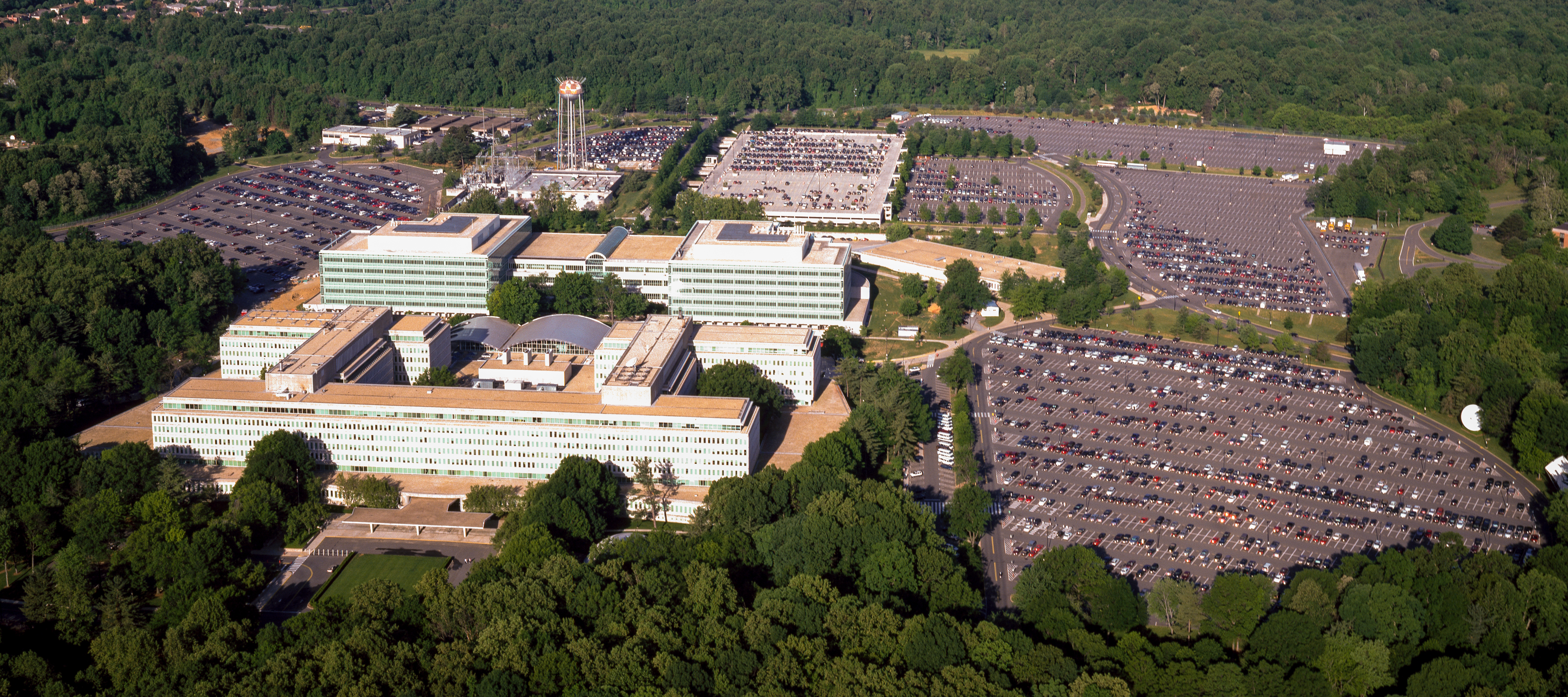
| Aerial view of the Central Intelligence Agency headquarters, Langley, Virginia
( |
|||||||||||||||||||||||||||
|---|---|---|---|---|---|---|---|---|---|---|---|---|---|---|---|---|---|---|---|---|---|---|---|---|---|---|---|
| लेखक |
|
||||||||||||||||||||||||||
| शीर्षक |
Aerial view of the Central Intelligence Agency headquarters, Langley, Virginia |
||||||||||||||||||||||||||
| Depicted place | Central Intelligence Agency headquarters | ||||||||||||||||||||||||||
| मिति | १९८० - २००६ | ||||||||||||||||||||||||||
| मझौलो | 1 transparency : color | ||||||||||||||||||||||||||
| आकारहरू | 4 x 5 in. or smaller. | ||||||||||||||||||||||||||
| Collection |
|
||||||||||||||||||||||||||
| वर्तमान अवस्थिति |
Prints and Photographs Division http://hdl.loc.gov/loc.pnp/pp.print |
||||||||||||||||||||||||||
| टिप्पणी |
|
||||||||||||||||||||||||||
| स्रोत |
|
||||||||||||||||||||||||||
| अनुमति (यो फाइल पुनप्रयोग गर्न) |
Rights Advisory: No known restrictions on publication. | ||||||||||||||||||||||||||
| अरु संस्करणहरू |
|
||||||||||||||||||||||||||


| | View this and other nearby images on: OpenStreetMap |
अनुज्ञा प्राप्त गर्दै
| This work is from the Carol M. Highsmith Archive collection at the Library of Congress. According to the library, there are no known copyright restrictions on the use of this work. Carol M. Highsmith has stipulated that her photographs are in the public domain. Photographs of sculpture or other works of art may be restricted by the copyright of the artist. |
 |
फाइल इतिहास
मिति/समय मा क्लिक गरेर त्यससमयमा यो फाइल कस्तो थियो भनेर हेर्न सकिन्छ ।
| मिति/समय | छोटो चित्र | आकारहरू | प्रयोगकर्ता | टिप्पणी | |
|---|---|---|---|---|---|
| हालको | २२:०२, २२ अप्रिल २०१७ | | ५,५२३×२,४५५ (७.५७ मेगाबाइटहरू) | Falcorian | User created page with UploadWizard |
फाइल प्रयोग
यस फाइलमा निम्न पृष्ठ जोडिन्छ:
विश्वव्यापी फाइल प्रयोग
निम्न अन्य विकिहरूमा यस फाइलको प्रयोग:
- ar.wikipedia.org मा उपयोग
- arz.wikipedia.org मा उपयोग
- ast.wikipedia.org मा उपयोग
- azb.wikipedia.org मा उपयोग
- az.wikipedia.org मा उपयोग
- br.wikipedia.org मा उपयोग
- ca.wikipedia.org मा उपयोग
- ce.wikipedia.org मा उपयोग
- cs.wikipedia.org मा उपयोग
- cy.wikipedia.org मा उपयोग
- da.wikipedia.org मा उपयोग
- de.wikipedia.org मा उपयोग
- en.wikipedia.org मा उपयोग
- eo.wikipedia.org मा उपयोग
- eo.wikiquote.org मा उपयोग
- es.wikipedia.org मा उपयोग
- fi.wikipedia.org मा उपयोग
- fr.wikipedia.org मा उपयोग
- fr.wikinews.org मा उपयोग
- ga.wikipedia.org मा उपयोग
- ha.wikipedia.org मा उपयोग
- he.wikipedia.org मा उपयोग
- hu.wikipedia.org मा उपयोग
- id.wikipedia.org मा उपयोग
- it.wikipedia.org मा उपयोग
- ja.wikipedia.org मा उपयोग
- ko.wikipedia.org मा उपयोग
- ky.wikipedia.org मा उपयोग
- lt.wikipedia.org मा उपयोग
- lv.wikipedia.org मा उपयोग
- mn.wikipedia.org मा उपयोग
- nn.wikipedia.org मा उपयोग
- no.wikipedia.org मा उपयोग
- ro.wikipedia.org मा उपयोग
- ru.wikipedia.org मा उपयोग
- ru.wikinews.org मा उपयोग
- sk.wikipedia.org मा उपयोग
यस फाइलको विश्वव्यापी उपयोगको अधिक जानकारी हेर्नुहोस् ।